

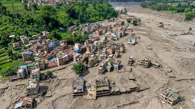
The catastrophe that struck northern Nepal on 26 August 2026 was not an ordinary monsoon flood. It was a violent cascade of geological and hydrological processes originating high in the Himalayas, where ice, rock, gravity and water combined to produce a destructive surge capable of travelling through valleys, overwhelming settlements and carrying devastation far downstream. Within hours, communities along the Bhote Koshi–Trishuli river system were transformed. Houses were buried in sediment, bridges disappeared, roads were severed, hydropower infrastructure was damaged and hundreds of families began searching for relatives who had simply vanished.
As of the early hours of 28 August, Nepal's National Disaster Risk Reduction and Management Authority was reported to have recorded around 400 bodies recovered and around 1000 people still missing, including hundreds of foreign nationals. Seventy-three people were reported injured, more than 13,000 security personnel had been deployed, fifteen helicopters were participating in rescue operations and nearly 2,000 people had been rescued by air. The figures remain fluid as recovery teams reach previously inaccessible areas.
What makes the disaster particularly important is that it represents something larger than a single tragic flood. It is a warning about the changing physical stability of the Himalayas themselves. Initial reports understandably produced confusion about the cause. Some suggested an earthquake had destabilised the mountains; others suspected a conventional glacial lake outburst flood. Satellite imagery and seismic analysis have since provided a clearer, although still preliminary, reconstruction.
The event appears to have originated near Langtang Lirung, a mountain more than 7,200 metres high in the Langtang Himalayan region. A huge mass involving glacier ice and rock collapsed from the mountain into the steep drainage system feeding the Lhende Khola, which ultimately joins the Bhote Koshi and Trishuli river system.
The significance of the seismic signal recorded at the time initially created speculation about an earthquake. The US Geological Survey, however, reported that the collapsing material itself generated seismic energy roughly equivalent to a magnitude 5.2 earthquake. In other words, current evidence indicates that the seismic event was principally a consequence of the enormous collapse rather than necessarily the cause of it. The Unites Staes Geological Survey (USGS) estimates that the resulting debris flow and flooding affected a corridor approaching 100 kilometres.
The distinction matters scientifically. Nepal experienced not simply "too much rain" but what disaster specialists describe as a cascading hazard. A high-mountain slope failed; glacier ice and bedrock collapsed; an avalanche accelerated down a steep valley; rock, ice and sediment entered the river system; temporary blockages and impounded water may have developed; and enormous quantities of debris and water were then released downstream.
The resulting flood wave travelled with extraordinary speed. International Centre for Integrated Mountain Development (ICIMOD) reported that at one monitoring point on the Trishuli River, the water level rose by approximately nine metres in only 30 minutes, while another station recorded a rise of around seven metres over a similar period. Such rates leave communities with almost no conventional reaction time once the flood is already approaching.
A dangerous Himalayan environment may involve unstable hanging glaciers, newly forming lakes, thawing permafrost, fractured bedrock, ice rock avalanches and temporary natural dams that can appear and fail within hours.
The river ceased behaving like ordinary water. It became a moving mixture of water, mud, boulders, trees, buildings and infrastructure. Such debris-rich floods possess much greater destructive power than clear-water flooding because their density and momentum allow them to batter structures rather than merely inundate them. Nepal's extraordinary landscape is simultaneously one of its greatest assets and its greatest physical vulnerabilities.
The country rises dramatically from the lowland Terai plains to the world's highest mountains over a relatively short horizontal distance. Rivers descend thousands of metres through steep valleys. Gravity therefore provides enormous potential energy to water and geological material released at altitude.
Northern Nepal also lies within one of Earth's most tectonically active environments. The Himalayas were created by the continuing collision of the Indian and Eurasian plates. The landscape consequently contains steep slopes, fractured rock and relatively young geological formations. Add glaciers, permafrost, snow, intense summer monsoon rainfall and rapidly flowing mountain rivers, and the ingredients exist for earthquakes, landslides, avalanches, debris flows, conventional floods and glacial lake outburst floods.
Human development has meanwhile concentrated valuable infrastructure within precisely these valleys. Roads follow rivers because mountains make alternative routes difficult. Hydropower facilities require steep river gradients. Settlements occupy limited areas of relatively flat ground beside rivers. Bridges funnel transport across narrow crossings. Tourism and pilgrimage routes use the same valleys. A single catastrophic river event can therefore damage several systems simultaneously. That is precisely what happened this week. Roads and bridges were destroyed, power infrastructure was damaged, settlements became inaccessible and rescue operations themselves were obstructed because the transport network required for rescue had been destroyed by the disaster. Perhaps the most disturbing aspect of the August 2026 disaster is that the same river corridor had suffered another major glacial flood only thirteen months earlier.
On 8 July 2025, a sudden flash flood struck Rasuwa after the rapid drainage of a supraglacial lake on the Purepu Glacier in Tibet, about 35 kilometres upstream from the Nepal-China border. Nepal's disaster authority subsequently concluded that a lake that had expanded on the glacier suddenly discharged water into the Lhende-Bhote Koshi system.
That earlier event killed people, destroyed the Friendship Bridge connecting Nepal and China, damaged roads, affected hydropower projects and devastated the Rasuwagadhi dry port. The recurrence is scientifically significant.
The 2025 disaster was associated primarily with the sudden drainage of water stored on a glacier. The 2026 catastrophe appears to involve a much larger ice-and-rock slope failure and debris cascade. They are different mechanisms, but they belong to the same emerging family of Himalayan cryospheric hazards.
The lesson is that risk assessment can no longer concentrate only on recognised large glacial lakes. A dangerous Himalayan environment may involve unstable hanging glaciers, newly forming lakes, thawing permafrost, fractured bedrock, ice-rock avalanches and temporary natural dams that can appear and fail within hours. The disaster has now entered two overlapping phases: rescue and secondary-risk management.
Search teams are attempting to locate hundreds of missing people across an enormous debris field. Among those missing are residents, workers, security personnel, tourists and pilgrims. The timing was particularly unfortunate because the region contained considerable tourist and pilgrimage traffic, including travellers associated with routes towards Kailash-Manasarovar.
Helicopters have become crucial because roads and bridges have disappeared in several areas. Heavy sediment makes conventional river searches difficult. Communications and electricity have been interrupted in affected locations, while damaged roads complicate the movement of excavators, medical teams, food, drinking water and emergency shelter.
There is also a grim geographical reality associated with mountain floods: victims may be transported enormous distances. Bodies have been recovered far downstream from the area where the initial catastrophe occurred. The flood moved from the Bhote Koshi into the Trishuli and subsequently through the wider river network.
The emergency is not over. Authorities in both Nepal and China have warned about newly formed debris-dammed lakes in the affected mountains. Water accumulating behind unstable natural barriers could produce another sudden release. Residents and even rescue personnel have therefore been warned to avoid vulnerable riverbanks in certain areas.
This represents one of the most dangerous characteristics of cascading disasters: the first event changes the landscape and creates the conditions for the second. A landslide can dam a river. The new lake fills. The dam consists not of engineered concrete but unstable rock, mud and ice. Eventually it may overtop or collapse. A second flood can then strike communities already weakened by the first.
It would be premature to claim that climate change has been conclusively established as the direct cause of the specific Langtang collapse. ICIMOD itself has cautioned that investigations are continuing and that attribution of an individual event requires analysis of hydrological, meteorological, geological, seismic and satellite data. But the broader climatic background is much clearer. The Hindu Kush Himalaya is warming, and its cryosphere is changing rapidly. Rising temperatures affect not merely how much glacier ice melts. They can influence the mechanical stability of entire mountain systems.
Ice that occupies fractures in rock can act as a form of cement. Permafrost can help stabilise high-altitude slopes. Repeated freezing and thawing, however, can open fractures. Melting glaciers remove support from valley walls. Meltwater can penetrate cracks. New lakes develop while existing lakes enlarge. Heavy rainfall can then interact with already weakened geological structures. Consequently, warming can transform not only glaciers but mountain stability.
ICIMOD reported in 2026 that glacier ice-loss rates across the Hindu Kush Himalaya have approximately doubled since 2000. A separate regional assessment found roughly a 12 percent reduction in glacier area between 1990 and 2020. Earlier research showed that glaciers were disappearing 65 percent faster during 2011–2020 than during the preceding decade.
This does not mean every avalanche can simply be labelled a climate-change disaster. It means the background environmental conditions within which avalanches, landslides and glacial floods occur are being altered substantially. That distinction is scientifically important.
Traditional flood warning systems typically measure rainfall and river levels. They work reasonably well when a flood develops gradually after prolonged precipitation. High-mountain cascading hazards are different. A glacier or mountainside may fail without extraordinary rainfall immediately beforehand. A river can suddenly become blocked. A temporary lake can develop outside an existing monitoring network. When that barrier collapses, the flood may travel downstream faster than warnings can move through conventional administrative channels. The August disaster demonstrated another weakness: the monitoring instruments themselves can be destroyed. Flood gauges in the upper river system were swept away.
Future warning architecture must therefore move upstream from simply measuring rivers to monitoring the entire mountain environment.That requires satellites, automated cameras, seismic sensors, glacier monitoring, lake-level sensors, weather stations, ground deformation measurements and continuous modelling. Artificial intelligence and automated anomaly detection could eventually help identify unusual movements or rapidly expanding lakes from satellite data. But instrumentation alone is insufficient. A warning that reaches a government office but not a villager beside the river has almost no humanitarian value. The final kilometre of disaster communication is as important as the satellite.
Recovery, however, cannot be reduced to reconstructing damaged infrastructure on the same vulnerable ground. The disaster should instead trigger a comprehensive geomorphological, hydrological and cryospheric reassessment of the Bhote Koshi-Trishuli corridor, identifying zones of channel migration, sediment deposition, slope instability, debris accumulation and possible temporary natural dams that could generate secondary hazards. Such mapping should form the basis of a stricter hazard-zonation regime in which schools, hospitals, hotels, markets, customs installations and other critical infrastructure are no longer permitted by default in areas exposed to extreme flood, debris-flow or landslide pathways.
Nepal will also have to rethink the engineering assumptions that underpin Himalayan hydropower development. Future projects cannot be designed solely around historical river discharge, conventional monsoon floods and standard return-period calculations; they must also account for low-frequency but catastrophic events involving glacial collapse, rock-ice avalanches, sudden lake drainage and exceptionally high sediment and boulder loads. Similar reforms are required along trekking and pilgrimage corridors, where visitor-registration systems, satellite-based communication, designated evacuation routes, emergency shelters and multilingual warning protocols should become standard components of mountain tourism. Most importantly, Himalayan risk management must move beyond national boundaries. Glaciers, rivers and unstable mountain systems operate across frontiers, and a hazard originating in one jurisdiction can threaten communities far downstream in another. Effective preparedness will therefore depend on sustained regional cooperation, real-time exchange of meteorological, hydrological and cryospheric data, shared satellite monitoring and interoperable early-warning systems. In the Himalayas, resilience will increasingly depend not only on stronger infrastructure, but on whether scientific knowledge can be translated into land-use regulation, engineering standards and rapid public warning before the next extreme event occurs.
The water that enters Nepal may originate in Tibet. Information about glaciers and lakes upstream may therefore be collected by Chinese institutions, while the population at risk may be downstream in Nepal and eventually India. The physical system does not recognise national sovereignty. Real-time China-Nepal-India hydrological and cryospheric data exchange is consequently not merely desirable diplomacy. It is life-saving infrastructure. World Meteorological Organization (WMO) has similarly emphasised that the Nepal disaster demonstrates the cross-border nature of Himalayan hazards and the need to close major gaps in observation and early-warning systems. Nepal has considerable experience responding to earthquakes, landslides and floods. Its security forces and local communities repeatedly demonstrate remarkable capacity during emergencies. The more difficult challenge is shifting investment from response towards anticipation.
Disaster preparedness is often politically unattractive because success is invisible. A bridge inaugurated after construction can be photographed. A hospital opened can be celebrated. Money spent monitoring an unstable glacier may produce nothing visible for years. Yet if that monitoring provides twenty minutes of warning before a catastrophic flood, its value becomes immeasurable.
Future Himalayan development therefore requires a different economic calculation. Monitoring stations, satellite analysis, resilient bridges, redundant communication systems and evacuation exercises must be treated not as optional environmental expenditure but as essential national infrastructure. The financial argument is straightforward. Preventing the destruction of a hydropower facility, highway or town can cost far less than reconstructing it after catastrophe. The Hindu Kush Himalayan system has often been described as the "Third Pole" because of the immense quantities of snow and ice stored across its mountains. Its glaciers and rivers influence the lives of nearly two billion people across Asia. Changes occurring at elevations where comparatively few humans live can therefore eventually affect water supplies, agriculture, energy systems and settlements across some of Earth's most densely populated regions.
For generations, mountains were treated as symbols of permanence. The Himalayas seemed almost immutable compared with the short scale of human life. Climate science is forcing a reconsideration of that assumption. The mountains themselves are changing. Glaciers are retreating. Lakes are appearing where solid ice previously existed. Permafrost is thawing. River behaviour is becoming less predictable. Slopes that remained stable under previous climatic conditions may not necessarily remain stable under future ones. The disaster of 26 August should therefore not be remembered only by its eventual death toll. That number, however terrible, represents the consequences of one event. The larger significance lies in what the catastrophe reveals.
Nepal stands at the frontline of a new category of environmental risk in which climate change, geology, glaciers, water and human development increasingly interact. The challenge is no longer simply learning how to survive floods after they arrive. It is learning to recognise how a warming mountain system is changing before the next wall of ice, rock and water begins its descent.
What has happened in the Bhote Koshi and Trishuli valleys is a national tragedy. But it is also a scientific warning from the Himalayas. Whether that warning becomes the foundation of safer development, or merely another chapter in a recurring cycle of disaster, mourning and reconstruction—will depend on what Nepal and the wider region do next. Because in a changing Himalaya, rebuilding the past may no longer be enough to protect the future.