

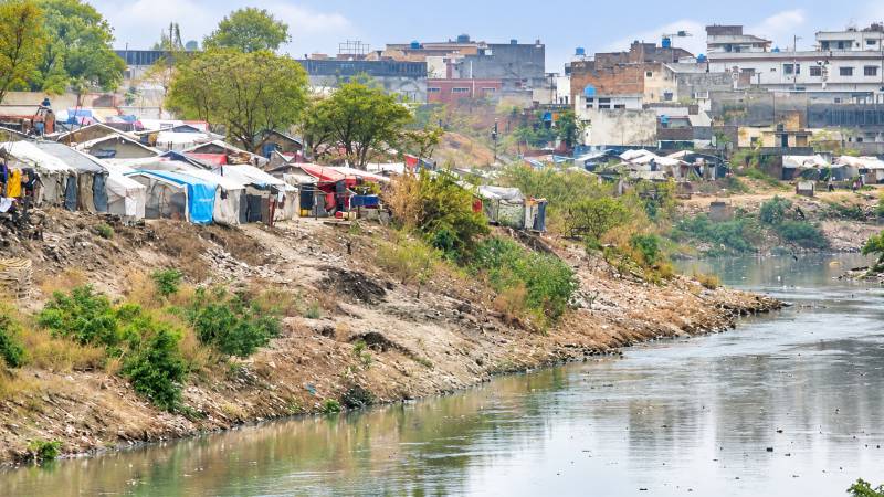
There are rivers that cities inherit, and there are waterways that cities gradually destroy. Nullah Lai, or Leh Nullah, is a painful example of the latter. What is commonly described today as a stormwater drain, in reality, a natural rain-fed river system that has carried runoff from the Margalla Hills through Islamabad and Rawalpindi before joining the Soan River. Over time, however, human settlement, encroachment, dumping and unplanned urban development have progressively squeezed this natural drainage corridor.
The Lai basin covers approximately 234.8 square kilometres and receives around 500 mm of average monsoon rainfall. Historical records examined by JICA identified 19 flood events between 1944 and 2004. But the warning written by nature became unmistakable on 23 July 2001, when nearly 620 mm of rain fell in only ten hours. The resulting flood killed 74 people and damaged or destroyed approximately 3,000 houses. That disaster triggered the JICA comprehensive flood mitigation study undertaken from 2002 to 2003.
The Lai does not begin in the middle of Rawalpindi. Its drainage system originates in the Margalla Hills and upper Islamabad. Saidpur Kas, Tenawali Kas and Bedarawali Kas are among its principal Islamabad tributaries, converging near Kattarian before the main channel enters Rawalpindi. Further downstream, it receives Nikki Lai, Pir Wadhai Kas and Dhok Ratta Nullah, together with other smaller drainage channels, eventually reaching the Soan River.
Its original width is an important subject requiring proper historical investigation. A natural river does not necessarily possess one uniform width from source to mouth. However, JICA's engineering investigations provide a revealing picture. Before improvement, several bottlenecks between Kattarian and Chaklala were less than 20 metres wide, with structures extending into the river channel. The subsequent engineering design envisaged top widths from approximately 47 metres to 69.7 metres, with a right-of-way generally between 56 and 79 metres.
This contrast tells the real story: a waterway capable of carrying enormous flood flows has been progressively compressed by the city around it. The frequently stated proposition that the historical natural corridor averaged more than 70 metres should, however, be established through old cadastral maps, historical surveys, aerial photographs, LiDAR and hydraulic reconstruction before being treated as a proven engineering fact.
The most dangerous aspect of Lai today is the creation of urban bottlenecks. At various locations, the river's effective width has been drastically reduced by construction, waste dumping, parking, cattle sheds and other encroachments. Ganjmandi, Gawalmandi, Pirwadhai, Dhoke Dalal, Dhoke Naju, Ratta Amral and adjoining settlements have repeatedly emerged as critical locations. Recent assessments have also identified 19 vulnerable points, extending from Kattarian through densely populated Rawalpindi to downstream areas. In Ganjmandi, reports have described the channel being reduced to only a few metres at one location because of dumping and encroachment.
This is not simply an environmental issue. It is a question of public safety. When extraordinary rainfall arrives, water does not negotiate with property boundaries, roads or illegal structures. It follows gravity and seeks its historical passage. Other countries have faced precisely this dilemma and made difficult decisions.
In Japan, the catastrophic 1910 Tokyo flood led to construction of the Arakawa Floodway, approximately 22 kilometres long and 500 metres wide. Around 1,300 households were relocated, while approximately 1,098 hectares of land were acquired. The project began in 1911, started carrying water in 1924 and was completed in 1930.
In the Netherlands, Nijmegen faced a dangerous bottleneck along the Waal River. Under the Room for the River programme, the existing dike was moved approximately 350 metres inland. Around 50 houses were removed, while a new bypass channel approximately 3 kilometres long and 150–200 metres wide was created. The project transformed flood protection into an opportunity for recreation and urban regeneration.
Even Pakistan has its own powerful precedent. In Karachi, the 16.5-kilometre Lyari Expressway was constructed along both banks of the Lyari River. JICA records approximately 15,000 homes demolished and 24,400 families relocated as part of the project. The scheme included substantial resettlement and also provided flood-protection functions to the river corridor. These examples demonstrate a difficult but unavoidable principle: when a waterway becomes dangerously constricted, cities sometimes have to move people and remove structures rather than move the river.
Rawalpindi cannot solve the Lai problem through annual desilting and emergency clearance alone. What is required is a new, comprehensive investigation based on the JICA studies, modern surveying and present-day realities. The entire corridor should be mapped through LiDAR and detailed topographic and cadastral surveys. Hydrological and hydraulic models should establish the required flood corridor and design discharge. Every bridge, culvert, retaining wall and obstruction should be assessed. Encroachments must be classified, and where unavoidable, lawful acquisition, compensation, resettlement and demolition should be undertaken.
The ultimate objective should be greater than flood control. A restored Lai could become a defining urban feature of Rawalpindi: a protected water corridor, with proper highways along both banks, engineered bridges, green belts, pedestrian areas and, where hydraulically and environmentally feasible, controlled recreational boating. The choice before Rawalpindi is therefore not between development and the river. It is between unplanned development that repeatedly puts lives at risk and planned development that gives the river back its space.
The experience of Japan, the Netherlands and even Karachi shows that difficult decisions can transform a dangerous waterway into an asset. Nullah Lai should no longer be treated as a seasonal nuisance waiting for the next monsoon. It is a river. It has a memory, a course and a capacity. If the city continues to narrow it, the flood will eventually reclaim what the city has taken away. The time has come not merely to clean Nullah Lai, but to restore it.