

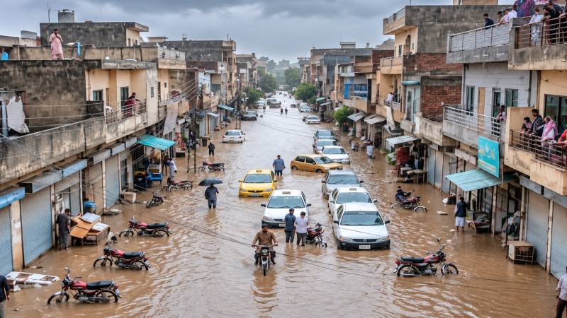
On September 1, 2026, the twin cities awoke to the first rainfall of the month. The consequences were dire as streets turned into rivers and nearby low-lying locations were flooded. People living around Nullah Lai had been instructed to leave their homes. The Pakistan Meteorological Department stated that Shamsabad recorded the most rain, with 197 millimetres, followed by New Katarian with around 185 millimetres and Golra with 157 millimetres. At the same time, the water levels also rose, with the levels at Katarian and Gawalmandi rising to 29 feet and 23.5 feet, respectively.
The answer is simple: too much rain. But after decades of warnings, the rain is not enough. There was a flood threat in Nullah Lai long before September 1; it has been an issue for generations. So, what transpired on September 1 was not merely a result of adverse weather. The weather exposed poor governance.
The Nullah Lai basin spans roughly 234.8 km². Nullah Lai originates in the Margalla Hills, runs through Islamabad and then through Rawalpindi. According to a JICA report, the Lai Nullah Basin extends across Islamabad and Rawalpindi, with Islamabad occupying the upper reaches and Rawalpindi the lower reaches. The flow of water, however, does not follow administrative boundaries.
The historical data is clear. JICA recorded 19 floods in the Lai basin between 1944 and 2004. The disaster of July 23, 2001, is regarded as the most compelling warning. Islamabad received 620 mm of rain in a 10-hour interval. There were 74 casualties, with about 3,000 houses destroyed. After this disaster, Pakistan and Japan conducted a full-fledged study of the problems of flooding, involving monitoring, forecasting and warning systems.
The issue was identified, but it did not resolve itself. Pakistan has an abundance of reports about Nullah Lai but does not have the means to translate these reports into tangible urban policy. Rainfall is just part of the story. Another part of the story is what happens after rainfall. A forest, open space or a field can absorb and store rain. Concrete cannot do that. Roads, roofs and paved areas contribute to runoff and lead to huge amounts of water flowing into drainage systems.
The Lai basin has been under study for years. The problem is no longer the absence of knowledge, but the failure to act on it.
Research published in the Landscape and Urban Planning journal projected that future land-use changes envisaged in the Islamabad Master Plan could increase total runoff by 51.6 to 100 per cent and peak discharge by 45.4 to 83.3 per cent. The assessment made by JICA had already identified the mechanism: development in Islamabad was causing the rise of peak flood runoff, while encroachments and waste were decreasing the discharge capacity of the River Lai downstream in Rawalpindi. The cities make the watershed less capable of absorbing rain while at the same time expecting the drainage systems to take on more of the burden. We pave the sponge and blame the drain afterwards for overflowing.
The reputation of Islamabad as a planned city hides this contradiction. Planning sector by sector is different from planning a watershed. Development in Islamabad influences the amount and speed of water going to Rawalpindi. Construction activities downstream, as well as encroachments, waste and narrowed channels, can limit the capacity of the system to remove this water. The basin of the River Lai goes through Islamabad, Rawalpindi and military establishments. The governance of the system is totally different from the system itself.
The issue is more complicated than just a planning failure; climate change is also changing the equation. In 2025, Rawalpindi witnessed a massive downpour that resulted in the city being inundated with rainfall of 230 mm in a span of just under 24 hours. One would be wrong to assume that this is simply a case of poor planning on our part without taking climate change into consideration. According to World Weather Attribution, climate change has increased the intensity of the heavy rainfall examined by around 15 per cent. The study also estimated that rainfall of this kind has a return period of approximately five years.
It is important to note that such statistics matter because they determine the manner in which infrastructure should be developed. Climate change changes the equation significantly; the problem now is with planning since organisations are not prepared for such impacts of climate change and thus do not pay attention to how floodplains are developed or how infrastructure is allowed to fall apart.
This must not become another cycle of emergency pumps and post-flood clean-ups. Some improvements must be made in the infrastructure, but the process has to start from upstream. Green belts and wetlands must be regarded as infrastructure. Rainwater must be retained using detention ponds and rain gardens, not let into the already stressed systems. Different approval processes must include watershed-level flood modelling. High-risk areas must not be built in, and relocation must be provided for vulnerable communities.
Islamabad and Rawalpindi need to collaborate on planning the Lai basin as a singular hydrological unit. A storm will not stop at Islamabad’s borders, and flood management should not either. When this is being read, the waters will have receded from the affected areas. Traffic will return to normal. Images of flooded roads will vanish from social media. And then will come the most dangerous period of forgetting.
The Lai basin has been under study for years. The disaster of 2001 resulted in the creation of plans, monitoring systems, and warning systems. Researchers have since shown that urbanisation can increase runoff and peak discharge. Thus, the message is clear. The following flood will not ask whether Pakistan is going to receive another report. It will instead ask whether somebody has done anything regarding the reports that have been lying in government archives all this time. Nullah Lai is not a villain but a natural phenomenon that reminds the two cities of the immutable law of nature that water flows downwards with no regard for administrative boundaries.