

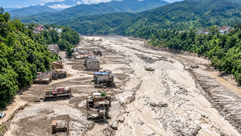
On 26 August 2026, flash floods tore through Rasuwa and Nuwakot in Nepal, killing people, destroying homes, and upending entire villages along the Bhote Koshi and Trishuli rivers. Our first obligation is to help the people affected: to those who lost their life, their homes, or their land, to the families who lost someone, to the villages that lost their footing, to Nepal as it works through the aftermath. The mechanism, as it is currently understood, is not the one Pakistan is used to reading about. Initial evidence points to the lower section of a glacier collapsing and falling roughly 1,200 metres, generating a surge of ice, rock, and debris that triggered sudden flooding downstream. The Trishuli reportedly rose several metres within half an hour of the surge arriving. This was not a monsoon event that got worse. Gilgit-Baltistan, Chitral, and the upper valleys of the Karakoram and Hindu Kush sit under the same kind of terrain that failed in Nepal: high-altitude glaciers, unstable moraines, and glacial lakes, feeding rivers that pass directly through inhabited valleys. Pakistan has already had a preview of this hazard, GLOF events and glacier-related flooding have hit Hunza, Chitral, and other northern valleys in past years. Nepal's disaster is not a foreign case study. It is a rehearsal for something Pakistan's own geography makes entirely plausible.
The response to Nepal's disaster has already picked its question: how do we detect the next one sooner. That question matters, and Pakistan should be asking it too. But it is not the question that determines whether an event like this becomes a catastrophe or a near-miss here. That question is the one almost nobody arriving after a disaster is positioned to ask, and that emergency response cycles are structurally built to skip: should there have been a settlement in that valley at all, and who decided that there should be. This piece is an attempt to ask it anyway, with Pakistan's own valleys specifically in view, not instead of the technical response Pakistan clearly needs, but before it, where it belongs.
The immediate response to an event like this is almost always the same, and for Pakistan it is the right instinct: we need better detection, monitoring, and better early warning systems. Continuous satellite monitoring of glaciers and glacial lakes in Gilgit-Baltistan and Chitral. Seismic and acoustic sensors near known unstable slopes. Faster data pipelines from sensor to siren, reaching villages that currently have none of this. There is real work underway on this front globally, including emerging research applying quantum computing methods to GLOF modelling, discussed this year with ICIMOD, JICA, and others working the problem in Nepal, work whose findings Pakistan's own disaster management authorities should be tracking closely. That work matters and deserves serious investment. Better detection can plausibly buy a few more minutes of lead time in Pakistan's northern valleys, narrow down which lakes and slopes are closest to failure, and make the warnings that do go out more targeted and more trusted.
Risk maps need to name unviable ground, not just hazard levels; a map that shades a valley high risk but still shows it zoned for new settlement, hydropower construction, or tourism infrastructure is not doing its job.
But it has a ceiling, and the ceiling is physical, not technological. When the trigger is a glacier collapse high on a mountain, often in terrain that crosses borders, as much of the glacial mass feeding Pakistan's rivers does, and carries no ground instrumentation at all, the achievable warning window is not measured in the hours a monsoon forecast gives you. It is measured in minutes, closer to earthquake alerting than weather forecasting. However good the sensors get, in Gilgit-Baltistan as much as in Rasuwa, they are detecting an event that has already started, not predicting one that has not. That is a narrower promise than "early warning" usually implies, and Pakistan's disaster planning needs to say so plainly rather than letting the phrase carry more confidence than the physics supports.
In May 2025, a rock-ice avalanche of exceptional scale destroyed the village of Blatten in the Swiss Alps. This is worth sitting with, because it is the cleanest test case available of what a well-functioning early warning system actually delivers, and it is directly relevant to what Pakistan should expect from its own investment in detection. Authorities had been monitoring accelerating slope movement for weeks. The warning worked. The village was evacuated in time. No lives were lost to the collapse itself. And the village is gone. Not damaged: gone. No engineering structure could have stopped the mountain from moving, and no early warning system could have changed that. What it could change, and did, was whether anyone was still in the village when it happened.
For Pakistan's northern valleys, this is the distinction that matters most. An early warning system answers the question of whether people will die today. It does not, and cannot, answer the question of whether anyone should live here at all. Those are different questions, and treating a good answer to the first as an answer to the second is exactly the mistake this piece is warning against, for Gilgit-Baltistan and Chitral as much as anywhere else.
This is not a one-off failure of judgement. It is a structural pattern, and it is already visible in Pakistan's own recent history with flooding, from the 2010 floods onward. When a disaster strikes, funding flows toward rebuilding what was lost, because that is fast, visible, and politically legible. Funding a relocation programme for a mountain community is slower, harder to sell, and offers no ribbon to cut. So the money goes to reconstruction, and reconstruction happens in the same place, along the same rivers, below the same unstable slopes. That reconstruction feeds a deeper paradox: every protective measure, an embankment, a monitoring network, an early warning system, makes a hazardous place feel safer than it actually is. Feeling safer attracts investment. In Gilgit-Baltistan specifically, that investment increasingly includes hydropower infrastructure and tourism development in valleys whose hazard profile has not actually changed. A generation later, the number of people and the amount of infrastructure behind that protection has grown far beyond what it was originally built to defend. The endpoint of that loop is a settlement, or a power station, whose location was never actually evaluated for viability, because by the time anyone with the expertise to evaluate it arrived, people and projects were already there, and the question had quietly become how to protect what exists rather than whether it should exist at all. The Netherlands is the multi-century, high-resolution version of this loop, made habitable through extraordinary engineering, and made permanent in the public mind by centuries of that engineering working. The loop that took the Dutch three centuries to run can complete in the Himalaya and Karakoram in a single generation, sometimes in a single event, as Nepal has just shown.
There is an obvious and fair objection to all of this, and it deserves to be met directly here in particular. Telling a household in upper Hunza, or a village in Chitral, that their location was the wrong address is not a fair moral claim on its own. Families in Pakistan's northern valleys did not choose that terrain the way the Dutch state chose to engineer the delta. They live where land, livelihood, and generations of history are, usually with no realistic alternative on offer. Calling that a wrong address and stopping there does not just miss the point, it launders responsibility away from the people who actually held it, and onto the people who had none. So it is worth naming plainly who held it, in the Pakistani context specifically. Provincial and federal planning authorities zone, or quietly permit, settlement and infrastructure in hazard-prone valleys because the land is otherwise unused and because the political cost of relocation or restriction is always higher, today, than the political cost of a disaster that has not happened yet. Donors and financing institutions, including those funding hydropower and climate adaptation projects across Gilgit-Baltistan and Chitral, fund construction in exposed valleys because a build has a bankable project cycle and a resilience-branded press release, and relocation does not; every dollar spent hardening a valley against the next flood is a dollar that made staying, or building, easier, and leaving harder. Insurance and relief mechanisms, where they exist in Pakistan, pay out in ways that treat the current location as fixed by default, because rebuilding in place is administratively simpler than relocating, not because it is safer. And the hydrology and disaster-risk profession, in Pakistan as everywhere, has largely accepted a mandate that starts after the siting decision is already made.
We arrive to protect what is there. We propose the early warning system, the monitoring network, the risk map, the evacuation plan, all useful, all downstream of a question we have collectively agreed is not ours to ask, which is whether anyone or anything should be here at all. Asking how to protect a valley is fundable, publishable, and uncontroversial. Asking whether that valley should carry more settlement or more infrastructure puts us in the room with land rights, provincial politics, livelihoods, and hydropower revenue, and most of us, understandably, would rather stay in the room with the sensors. None of these actors carry the consequence when the valley floods. The residents do. That asymmetry, between who decides and who bears the loss, is the actual accountability this argument demands, in Islamabad and Gilgit as much as in The Hague.
None of this argues against early warning systems. Pakistan urgently needs far better detection than exists today across its northern valleys. What has to change is what that investment is allowed to stand in for. Risk maps need to name unviable ground, not just hazard levels; a map that shades a valley high risk but still shows it zoned for new settlement, hydropower construction, or tourism infrastructure is not doing its job, and honest risk-mapping across Gilgit-Baltistan and Chitral has to be willing to name specific valleys, moraine-dammed lakes, and glacier-fed reaches that should not carry new population or new infrastructure, as a binding planning constraint rather than a hypothetical. Financing needs to fund relocation as readily as it funds resilience; as long as a monitoring station is a fundable line item and helping a community relocate is not, donors and provincial authorities will keep choosing the former, because it is the project that gets approved, and that is a financing-instrument problem that Pakistani institutions negotiating international climate finance are well placed to help fix. And the profession needs a norm of stating the limit, not just the system; every early warning system delivered to a community or government body in Pakistan's north should come with an explicit, written statement of what it does not solve, the residual risk, the population with no realistic evacuation route in the available lead time, the fact that being warned is not the same as being safe.
Build the early warning systems. Fund the sensors, the satellite monitoring, the research into faster detection, GLOF and glacier-collapse events deserve every bit of technical effort Pakistan and its partners can put toward them. That is not in question. What is in question is whether Pakistan lets that effort answer a question it was never capable of answering. Blatten shows what a warning system can do at its absolute best: it can get everyone out in time. It cannot make the mountain stop moving, and it cannot make a valley that was never viable into one that is. Rasuwa and Nuwakot deserve the same honesty the Alps eventually got, and so do Gilgit-Baltistan and Chitral, before their own next event, not after it.