

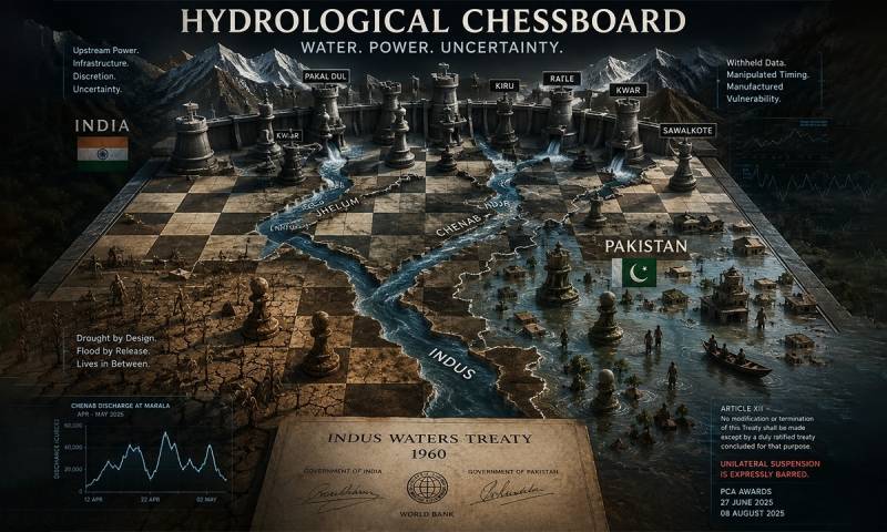
For more than six decades, one of the world's most unlikely diplomatic achievements quietly endured between two nuclear-armed states that have fought four wars. The Indus Waters Treaty, brokered by the World Bank in 1960 after nine years of negotiations, divided the rivers of the Indus Basin between India and Pakistan: the three eastern rivers (the Ravi, Beas, and Sutlej) to India, and the three western rivers (the Indus, Jhelum, and Chenab) largely to Pakistan, with India permitted limited non-consumptive use.
Former United States President Dwight Eisenhower called it "one bright spot in a very depressing world picture." It has since been cited as the gold standard of transboundary water governance: proof that even hostile states can build durable cooperative frameworks over shared resources.
On 23 April 2025, India declared that framework in abeyance. What followed was not merely a diplomatic rupture. It was the withdrawal of legal governance from an entire river system on which 250 million people depend, and the opening of a question that will outlast this bilateral crisis by decades: whether international water law retains meaning when a powerful upstream state decides, unilaterally, that it no longer applies.
This is not the first time India has used its upstream position as leverage over Pakistan's water. In 1948, less than a year after partition, India closed the headworks controlling canals that flowed into Pakistan, cutting off irrigation to vast areas of Punjab at the height of the sowing season. That crisis drove twelve years of diplomacy, World Bank mediation, and the creation of an Indus Basin Development Fund to compensate Pakistan for the rivers it ceded.
The treaty was, at its core, an acknowledgement that upstream power without constraint is an existential threat to a downstream agricultural economy. What is unfolding now is the recurrence of that dynamic, pursued through infrastructure and legal abeyance rather than the closing of headworks, and therefore more difficult to see, more difficult to measure, and more difficult to reverse.
India's invocation of abeyance following the Pahalgam attack, in which 26 civilians were killed in Indian-administered Kashmir, was framed as a security response. Legally, it has no basis. Article XII of the treaty is unambiguous: any modification or termination requires mutual consent. Unilateral suspension is not merely absent from the treaty's provisions. It is expressly barred. The Permanent Court of Arbitration, constituted under the treaty's own dispute-resolution mechanism, confirmed this in its Supplemental Award of 27 June 2025 and reaffirmed its jurisdiction in its Award on Issues of General Interpretation of 8 August 2025.
India rejected both rulings and has not returned to the proceedings. The Vienna Convention on the Law of Treaties requires mutual consent for termination under Article 54, and permits suspension only in cases of fundamental change of circumstances under Article 62. The International Court of Justice, in Gabcikovo-Nagymaros (1997), explicitly rejected security grievances as grounds for suspending shared resource agreements. India's position fails each of these tests. An international court has said so. India has not shown up.
India's defenders offer three arguments that deserve a direct answer. The first is that the 2025 monsoon floods were a natural phenomenon: reservoirs filled to capacity during an exceptionally heavy monsoon, releases were unavoidable acts of flood management, and India's own territory was simultaneously devastated, evidence, they say, that the releases were not targeted.
The second is that India did issue flood warnings to Pakistan, on humanitarian grounds, despite the abeyance. The third is that the treaty is a 1960 instrument ill-suited to modern conditions, making India's push for renegotiation a reasonable sovereign position rather than bad faith.
On the first: the treaty's coordination architecture existed precisely for moments of unavoidable release. Under the treaty, a dedicated Flood Cell operated in Pakistan's Commissioner's office from 1 July to 10 October each year, working around the clock to receive and disseminate advance flood information, not generic alerts, but daily, site-specific data covering river levels, discharge volumes, expected timings, and projected inundation zones across all six rivers.
What India provided in August 2025 were skeletal diplomatic notes, often containing little more than a "high flood" classification, routed through the Indian High Commission rather than the Commission mechanism, leaving Pakistani authorities, in the words of Pakistan's former Federal Flood Commissioner, receiving information "in a very generic way."
By 2030, the country faces a projected water deficiency of up to 50%
On the second: Pakistan's Foreign Office noted immediately that the warnings were conveyed through diplomatic channels rather than the Indus Waters Commission as the treaty requires, and an Indian official confirmed they were issued on humanitarian grounds and not under the treaty. A warning issued outside the treaty framework does not fulfil treaty obligations. It demonstrates that India understands those obligations exist while choosing to perform them selectively and on its own terms.
On the third: the case for updating the treaty may have merit in the abstract, but it does not justify unilateral suspension. The Vienna Convention is clear. A party wishing to modify or exit a treaty must do so through the treaty's own procedures or through negotiation. India has done neither. It has declared the treaty inoperative and continued building.
The practical consequences of the abeyance extend across all three western rivers simultaneously. On the Jhelum, India's Kishanganga project, whose design was contested before the Court of Arbitration for years, with Pakistan arguing it would reduce downstream flows into the Neelum valley, now operates without the transparency and data-sharing obligations the treaty required.
On the Indus itself, while India's current infrastructure remains limited, the removal of treaty constraints eliminates the legal barriers to future storage works that would otherwise require Pakistan's knowledge and consent. On the Chenab, where the cascade of Indian infrastructure is most advanced, the consequences are already measurable in the discharge record.
The human cost of the abeyance became measurable in August 2025. Beginning on 20 August, the Chenab, Ravi, and Sutlej entered simultaneous exceptionally high flood, the highest such levels recorded since 1988. Indian dams in Jammu and Kashmir, Himachal Pradesh, and Indian Punjab reached capacity and released large volumes downstream, triggering emergency evacuations across multiple districts of Punjab.
By the end of August, initial Pakistan National Disaster Management Authority figures recorded over 4 million people affected in Punjab, with hundreds of thousands displaced; nationwide, more than 2.2 million hectares of cropland were submerged and 8,400 villages inundated. More than 300 people died in Punjab alone, the worst flooding since 1988.
The Ravi's case deserves particular attention. The treaty allocated the Ravi to India as an eastern river. Over the decades since 1960, India's dams reduced the Ravi to a fraction of its historical size as it crossed into Pakistan. Communities built permanent settlements on what had become dry riverbed: legally documented properties with electricity connections, gas supplies, and titles registered through formal mutation records. They were safe to do so because the treaty made the Ravi predictable.
When Indian reservoirs released in August 2025, flash floods reached 220,000 cusecs at Lahore's Shahdara point, the largest flow recorded since 1988, inundating parts of Lahore itself. Those communities had no structured advance warning because the treaty mechanism designed to provide it had been suspended four months earlier by India's own declaration. The treaty did not merely allocate water. It created the conditions under which people built their lives.
The monsoon episode illustrated the flood dimension of abeyance. The spring pattern on the Chenab illustrates the other: timing as an instrument of upstream control. WAPDA's hourly discharge record at Marala, the principal gauging station where the Chenab enters Pakistan, shows a river that did not behave as weather or snowmelt would predict during April and early May 2026.
Flows surged from baseline into a pronounced peak, settled into a depressed band for over a week, then rose again, only to fall by more than half within twelve hours on 2 May. This was the second such cycle in twenty-four days, in the absence of any rainfall in the catchment. One such episode could be attributed to routine reservoir flushing. Two in immediate succession is a behavioural signature: a river being operated, not a river responding to nature. The agricultural consequences are immediate and specific.
Pakistan's Punjab, the backbone of the country's wheat, rice, cotton, and sugarcane production, depends not on seasonal water averages but on precise timing. Early Kharif is a narrow window. Even a week's disruption delays germination, forces farmers onto groundwater reserves already at the edge of their sustainable yield, and compresses planting schedules in ways that reverberate through the entire season.
The scale of dependence is difficult to overstate. The Indus system irrigates more than 80% of Pakistan's cultivated land. Pakistan's per capita water availability has fallen from 5,260 cubic metres in 1951 to around 900 today, well below the international scarcity threshold of 1,000 cubic metres, according to the National Water Policy 2018.
By 2030, the country faces a projected water deficiency of up to 50%. The Indus Delta is dying from salinisation and sea intrusion as reduced freshwater flows fail to push back tidal incursion, destroying wetland ecosystems and the fishing communities that depend on them. A country already at that margin cannot absorb manufactured variability across its primary river system without consequences that reach far beyond agriculture into food security, public health, and political stability.
The river system is not being seized overnight. It is being recalibrated, one dam at a time, one withheld dataset at a time, behind the screen of a legal abeyance that no court has sanctioned and no treaty permits
What makes the current situation structurally different from any previous dispute is not a single dam or a single flood season but a coordinated pipeline of infrastructure whose cumulative effect transforms India's upstream position permanently. In May 2025, two Reuters reports, one drawing on a government document and the other on six government sources, disclosed that Prime Minister Modi had ordered officials to expedite work on the western rivers, that the start dates of four Chenab projects (Pakal Dul, Kiru, Kwar, and Ratle) had been advanced by months, and that planning was under way to expand the Ranbir canal on the Chenab.
Each project, India argues, complies individually with the treaty's volumetric limits under Annexure D, which permits run-of-river hydropower but restricts pondage to daily generation rather than seasonal control. Collectively, however, they enable something the treaty did not anticipate: the ability to shape the timing of flows across an entire river system without formally exceeding those limits. The treaty regulates dams. It does not regulate a system of dams.
Pakal Dul, targeted for commissioning in December 2026, will introduce the first significant storage element into the Chenab cascade, with live storage capacity roughly three times the pondage of the existing Baglihar dam, which has itself been the subject of a decade of legal dispute. Beyond it sits Sawalkote, the largest project yet approved on the river, for which India's state-owned NHPC floated a civil works tender worth INR 5,129 crore in February 2026.
The Sawalkote approval is particularly revealing: India's Forest Advisory Committee, in its June 2025 minutes accessed by the Hindustan Times, cautioned against undertaking basin-wide hydrological studies, citing the risk of exposing sensitive data to "downstream neighbouring countries" and potentially compromising national security. A government body has placed infrastructure on a river flowing into Pakistan outside the reach of environmental accountability and transparency.
At the existing Salal dam, engineers have reopened flushing gates and are dredging to restore storage capacity silted up over decades. Infrastructure neutralised by years of accumulated silt is being reactivated. The abeyance has not merely changed a legal status. It has opened sealed gates, literally, while removing the legal architecture that governed what flowed through them.
The Ranbir Canal expansion makes India's intent still more explicit. India announced plans to expand the canal's capacity from 40 to 150 cubic metres per second (over 5,200 cusecs), vastly exceeding the treaty's irrigation limits, which cap India's withdrawals from the Chenab at 1,000 cusecs in summer and 350 in winter. Annexure D, Paragraph 7 of the treaty mandates prior notification for precisely such works. None was given. The expansion was announced days after a fragile ceasefire.
India's Union Jal Shakti Minister C.R. Patil declared on 25 April 2025 that the government would ensure "not a single drop" of Indus water reaches Pakistan. A ministerial statement of that kind, combined with a documented acceleration of infrastructure and a treaty suspended by declaration rather than by law, constitutes something the international community should be willing to name: the systematic construction of coercive upstream capacity.
Compounding the operational reality is the deliberate erasure of transparency across all three western rivers simultaneously. Article VI of the treaty requires regular exchange of hydrological and operational data. Article VIII mandates the functioning of the Permanent Indus Commission. India has fulfilled neither obligation since April 2025. Formal requests from Pakistan's Commissioner, issued in December 2025 and again in May 2026, have gone unanswered.
The consequence is that Pakistan is left to infer upstream intent from downstream behaviour on the Indus, Jhelum, and Chenab simultaneously, reading discharge records as proxies for dam operations, because the data that would clarify that intent is being withheld as a matter of documented policy. In such conditions, even technically compliant infrastructure generates strategic uncertainty at the scale of an entire river system.
India's conduct carries risks that extend well beyond South Asia, risks that India itself should recognise. As a lower riparian to China on the Brahmaputra and the Sutlej, India depends on rivers originating in Chinese-controlled Tibet. China has built or is planning infrastructure on these rivers of a scale that dwarfs anything India has constructed on the western rivers, including the proposed 60,000 MW Motuo mega-dam on the Brahmaputra, whose scale and operating profile have prompted significant Indian concern about timing manipulation, sediment disruption, and data withholding in the years ahead.
If India establishes the precedent that upstream powers may suspend water-sharing obligations by invoking security concerns, it furnishes Beijing with precisely the justification it would need to do the same. The norm that water treaties survive political disputes protects India as much as it protects Pakistan. By eroding that norm, India is not wielding a weapon against Pakistan alone. It is dismantling a shield it will one day need for itself.
The implications extend further still. More than 300 transboundary river agreements govern critical water flows worldwide, among them the Nile Basin Initiative among Egypt, Sudan, and Ethiopia; the Mekong River Commission among Southeast Asian states; and the Danube conventions in Europe. These frameworks are already under pressure from climate change, population growth, and competing national demands.
A successful Indian breach of the foundational norm that water agreements survive political disputes could trigger cascading reassessments from the Nile to the Mekong. The Indus Waters Treaty has long been cited as proof that water cooperation is possible even between enemies. Its effective dismantling removes that proof from the record at precisely the moment when the world needs such proof most.
The treaty is also showing its age in ways that demand international attention independent of the current crisis. Signed in 1960, it contains no provisions for environmental flows, makes only vague mention of pollution control, and excludes climate science from its governance architecture entirely.
The Indus Basin's glaciers are melting at an accelerating rate, upending seasonal flow patterns and making timing-dependent agriculture more vulnerable precisely as upstream infrastructure expands its capacity to manipulate those patterns. A treaty designed for a different climate, a different hydrology, and a different geopolitical moment is being stress-tested at the worst possible time by the worst possible conduct.
The international community's interest is not merely in enforcing the existing treaty. It is in ensuring that whatever framework replaces or updates it is more transparent, more adaptive, and more climate-aware than the one currently being unilaterally dismantled.
What Pakistan is asking the international community to recognise is not a bilateral grievance. It is a question of institutional integrity. The Permanent Court of Arbitration has ruled twice, in its Supplemental Award of 27 June 2025 and its Award on Issues of General Interpretation of 8 August 2025. The Vienna Convention applies.
The Gabcikovo-Nagymaros precedent is established. The World Bank, as a signatory to the treaty, has standing and responsibility. The question is whether these institutions and the norms they embody retain meaning when a large upstream state rejects their authority, accelerates its infrastructure in defiance of their rulings, withholds hydrological data as a matter of documented national security policy, and frames the entire exercise as beyond international scrutiny.
If the answer is that they do not, that a sufficiently powerful state can suspend international water law by declaration, then the 300 agreements governing the world's transboundary rivers are worth considerably less than the paper they are written on.
The Indus system does not understand politics. Its rivers flow downhill, carrying snowmelt from the Himalayas and the Karakoram toward the fields and cities of the plain, indifferent to courtrooms and communiqués. Whether those flows arrive in the right volume at the right time, whether they arrive at all when they are needed, and recede when they should, will be determined partly by what India builds and operates in Kashmir, and partly by whether the international community treats the erosion of water law as someone else's problem until it becomes everyone's.
The river system is not being seized overnight. It is being recalibrated, one dam at a time, one withheld dataset at a time, behind the screen of a legal abeyance that no court has sanctioned and no treaty permits. The question is whether the response, legal, diplomatic, or institutional, will match the scale and the urgency of what is being lost.