

Pakistan is debating a new constitutional order as if water will adjust afterwards. It will not. In 1947, the Radcliffe Line was drawn across Punjab with little consideration for the region’s interconnected water system. Within months, supplies to canals flowing into Pakistan from headworks that now lay on the Indian side were interrupted. The lesson was clear: a political boundary could turn hydraulic dependence into strategic leverage.
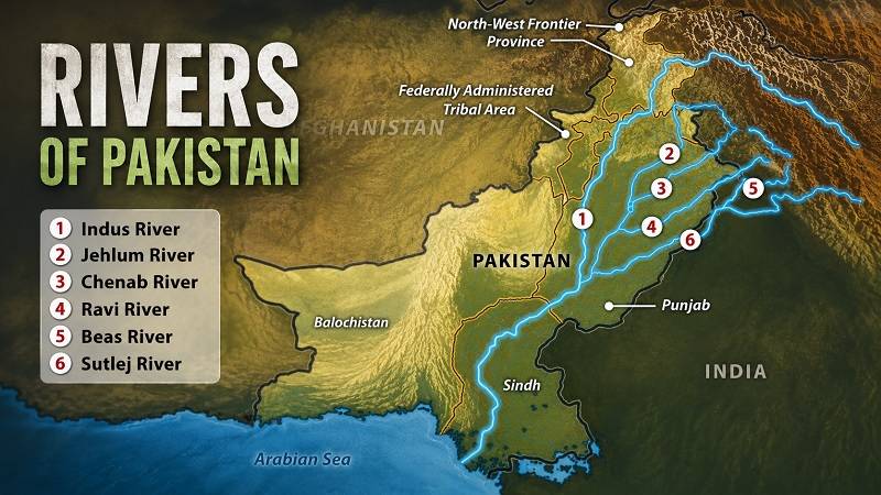
It took a decade of negotiation, World Bank mediation and financing to turn that emergency into the Indus Waters Treaty of 1960. The treaty assigned the Ravi, Beas and Sutlej to India, and the Indus, Jhelum and Chenab to Pakistan. But the settlement did not leave Pakistan’s canal economy as it was. Bahawalpur’s Sutlej Valley works had depended on the Sulemanki, Islam and Panjnad headworks, while the Ravi irrigated a vast stretch of central Punjab down to Khanewal. With the eastern rivers no longer available as before, Pakistan had to sustain these historically developed commands through a planned system of replacement storage, link canals and remodelled works.
That history should make us humble. The last time a political boundary was drawn across this basin before its water arrangements were settled, Pakistan needed mediation, replacement storage and a generation of works. Today we are debating more units, federal territories and a stronger centre, as if the river will adapt.
I declare an interest. I have served three terms in the Punjab Assembly representing a South Punjab constituency, including one term as Punjab’s irrigation minister, and I want South Punjab to have its own province. But I also know the cost of drawing the map first and discussing water later. No final draft has settled the question, which is why the water question must be asked now.
Article 239 is often quoted as a barrier. It is better understood as leverage. A constitutional amendment needs two-thirds of the total membership of each House. A bill altering provincial limits also requires the affected assembly to approve it by two-thirds of its total membership. Article 239 can determine the constitutional procedure for changing a boundary; it does not, by itself, settle the hydraulic consequences of that boundary. Consent given before entitlement, rotation, telemetry, Kotri and shared headworks are settled is consent given blindly.
Telemetry must define the point of measurement, the audit trail and the public data standard before new boundaries multiply the points of suspicion.
The divisional template is tempting because the districts and offices already exist. But administrative geography and hydraulic geography are not the same. Districts follow revenue lines; irrigation follows rivers, doabs, barrages and commands. When a river becomes a boundary, every barrage acquires a left-bank government and a right-bank government.
A stronger centre may claim coordination. But coordination is not settlement. A centre able to order a canal closure may not be bound by entitlements, telemetry, drought rules, audits and downstream obligations. Power created before law is not a water settlement.
The map would create gatekeepers. Balloki would sit in a Lahore-centred unit, yet control the Lower Bari Doab system toward Khanewal and the Balloki-Sulemanki Link toward Bahawalpur. Trimmu, in Jhang, would add another point of control over flows into South Punjab. Taunsa, in Dera Ghazi Khan, makes the point from the other side: South Punjab would control the Taunsa-Panjnad Link toward Bahawalpur and the Kachhi Canal toward Balochistan. A divided Punjab could therefore place the same political unit downstream at Balloki and Trimmu, yet upstream at Taunsa. Under one Punjab, these are operational questions. Under divided provinces, they become questions of power.
Stand at Sukkur. One barrage feeds seven major canals, whose systems reach across upper and lower Sindh. At Guddu, the Pat Feeder and associated channels carry water toward Balochistan; at Sukkur, the Kirthar system provides another cross-boundary supply. Kotri is the last major control point before the sea. The flows released below it help check seawater intrusion and sustain the delta. If Karachi becomes a federal territory, the federation becomes a water claimant while the works that supply it remain in another jurisdiction. Gwadar teaches the opposite lesson: a port can be designated for strategic purposes, but it cannot import a river.
Balochistan is part of the same hydraulic map. Canals originating at Sindh barrages carry water into Balochistan: Pat Feeder and associated channels from Guddu, and the Kirthar system from Sukkur. Balochistan’s concerns about timely and measured supplies are a reminder that interprovincial water questions do not stop at Punjab’s borders. Kachhi makes the same point from within: a canal can be substantially built and still not deliver its intended command. If these questions remain unresolved among four provinces, multiplying governments will not soften them. It will give every shortfall a new address.
The recent telemetry debate shows why measurement cannot be an afterthought. A federal project meant to improve real-time water accounting has raised questions between Sindh and Balochistan about where gauges should be located: at the barrage, or at the point where water is released across the boundary. The concern is not merely technical. Measurement location can determine whether data ends a dispute or starts one. Telemetry must define the point of measurement, the audit trail and the public data standard before new boundaries multiply the points of suspicion.
The post-1960 link canals were built to reconnect domestically what Partition had divided internationally. Chashma-Jhelum, Taunsa-Panjnad, Qadirabad-Balloki, Balloki-Sulemanki and Trimmu-Sidhnai are not just canals; they are strategic links within one interconnected system. The 1991 Accord did not create four separate water systems. It created provincial shares in one. A provincial boundary can divide responsibility for a watercourse, but it cannot divide the behaviour of the water itself. Groundwater is even less obedient. A province can regulate tube wells, but it cannot stop an aquifer from crossing a boundary.
The Accord did not finish the job. It recognised the need for storage, but recognition has not become storage. It also recognised the need for flows below Kotri, but left the quantity to further study. Official data show that about 90 percent of flows below Kotri occur in Kharif, while Rabi frequently sees very low or no-flow days. The delta needs a seasonal floor, not an annual excuse. Kachhi’s main canal is substantially built, but command-area development has lagged. The proposed Chashma Right Bank lift-cum-gravity project in Khyber Pakhtunkhwa remains unbuilt. Paper infrastructure is not outlet delivery.
The deepest division is upstream against downstream. Splitting provinces may create more upstream actors without giving the downstream voice greater protection. Sindh’s political representation could rise while its position as a single lower riparian weakens. South Punjab must be honest about the trade-off. A provincial capital is worth little if the province inherits canals without securing the headworks and links they depend on or discovers too late that it controls gates for others while waiting for gates controlled from Lahore.
When water runs short, losses are often inferred as a residual: what entered, minus what left, minus withdrawals. Seepage, evaporation, inefficiency and theft become one unexplained balance because measurement is weak. Shortage cannot be managed through equal percentage cuts. Below usable discharge, canals lose command and tail reaches fail. The system therefore runs on rotation, and rotation requires an authority trusted to say no repeatedly during drought.
Picture the first dry year after notification. Upstream units protect their crops. Downstream units invoke their entitlements. A federal city demands lifeline supply. The delta demands flow. A rotation order closes a canal under another government’s control. The case reaches court after the sowing is lost. You cannot litigate a hydrograph. A crop has no lawyer.
This is not a defence of the status quo. Large provinces often manage last-mile water badly. Watercourse maintenance, abiana collection, outlet tampering and tail-end distress all require government closer to the farmer. Delivery can be devolved. Basin allocation cannot.
So the issue is not whether Pakistan can have more provinces. It is whether anyone is prepared to define, in law, how those provinces will share one river system. No province bill, federal territory bill or district scheme that changes control over an Indus command should reach a final vote until five schedules are settled in law. First, entitlements and their allocation formula. Second, the governance of shared headworks, barrages, link canals and reservoirs, including operators and costs. Third, drought rotation rules. Fourth, telemetry, audit and public data. Fifth, lifeline and downstream obligations, including Kotri, framed as an enforceable seasonal flow regime with minimum flows and ecological timing rather than a single annual average. Parliament, IRSA and the provincial irrigation departments should prepare and ratify these schedules before any boundary is moved.
A provincial boundary can divide responsibility for a watercourse, but it cannot divide the behaviour of the water itself. A province can regulate tube wells, but it cannot stop an aquifer from crossing a boundary.
Article 239 should exact that price. The required two-thirds consent should not be given until the water schedules are settled and ratified. Their core entitlements, jurisdictional arrangements and allocation rules should not later be alterable through ordinary legislation or administrative order, while technical operating standards can be updated under the settlement rather than outside it. No new boundary should cross an Indus command without a prior water settlement covering everything that boundary divides.
The arguments over the number of new provinces may change. The river system will remain the same. I want South Punjab to have its province. But 1947 taught us the cost of drawing boundaries first and asking about water later. Whatever map Pakistan ultimately chooses, the water settlement must come first. A province that cannot say where its water comes from, who controls the gates and what happens when the river runs short is not yet a workable province. It is a boundary waiting for a crisis.
Annex: Canals That Cross the Proposed Political Map
Illustrative only, under the assumed proposed map. Current district locations may fall differently once boundaries are drawn. The table separates existing hydraulic facts from assumed boundaries and the governance problems that would follow.
| Existing hydraulic fact | Assumed political boundary | Resulting governance problem |
| Balloki Headworks on the Ravi controls the Lower Bari Doab Canal toward Khanewal and the Balloki-Sulemanki Link toward the Sutlej valley. | Balloki lies in a Lahore-centred unit; the commanded areas extend toward South Punjab and Bahawalpur. | A downstream province can depend on gates and transfers controlled from another province. |
| Trimmu Barrage at Jhang regulates flows into the Trimmu-Sidhnai Link and toward the Sidhnai and Khanewal side. | Trimmu lies in Jhang, while the dependent command extends into South Punjab. | South Punjab’s supplies can depend on an upstream control point outside its jurisdiction. |
| Taunsa Barrage in Dera Ghazi Khan feeds the Taunsa-Panjnad Link toward Bahawalpur and the Kachhi Canal toward Balochistan. | Taunsa lies in a proposed South Punjab unit, while Bahawalpur and Balochistan are separate units. | South Punjab would be downstream at Balloki and Trimmu but upstream at Taunsa, making reciprocity unavoidable. |
| Kachhi Canal takes Indus water from Taunsa into Balochistan; the main canal is substantially built, but command-area development has lagged. | The origin lies in a proposed South Punjab unit and the command lies in Balochistan. | Physical works, outlet delivery and provincial entitlement must be settled separately. |
| Guddu Barrage feeds Sindh canals and the Pat Feeder, Uch and Manuthy systems for Balochistan; Kirthar is a separate Sukkur-side supply. | The barrage remains in Sindh while the claimant command lies in Balochistan. | Releases, losses and measurement points can become a continuing interprovincial dispute. |
| Sukkur Barrage feeds seven major canals serving upper and lower Sindh. | Proposed divisions or a Karachi federal territory could place claimants and works in different jurisdictions. | A single barrage could face multiple governments with competing claims. |
| Kotri is the last major control point before the sea; about 90 percent of flows below it occur in Kharif, with frequent very low or no-flow Rabi days. | The barrage and delta obligations sit within Sindh while Karachi may become a federal territory. | The delta needs an enforceable seasonal flow regime that survives boundary changes. |
| Rasul-Qadirabad moves Jhelum water to the Chenab; Qadirabad-Balloki transfers it onward to the Ravi. | The works and receiving systems may fall in different northern, central or Lahore-centred units. | Replacement supplies cross internal boundaries and require common operating rules. |
| Sidhnai-Mailsi-Bahawal links the Ravi system toward Mailsi, Bahawal and Sutlej channels. | The headreach may lie in South Punjab while the receiving command extends toward Bahawalpur. | Works built for one command would require shared scheduling across provinces. |
| Chashma-Jhelum transfers Indus water into the Jhelum system as part of the post-1960 replacement network. | The origin and receiving commands may fall in different units. | A provincial boundary cannot separate replacement water from the storage and operating rules that sustain it. |
| The federal telemetry programme covers key barrages and offtakes, including Guddu, Sukkur, Kotri, Pat Feeder, Kirthar, Uch and Manuthy. | Sindh and Balochistan have raised different concerns about where releases should be measured. | Gauge location, audit and public data standards must be settled before boundaries multiply suspicion. |
| The proposed Chashma Right Bank lift-cum-gravity project in Khyber Pakhtunkhwa remains unbuilt. | Its planned command lies in Khyber Pakhtunkhwa. | Paper infrastructure cannot be treated as delivered entitlement when boundaries are drawn. |