

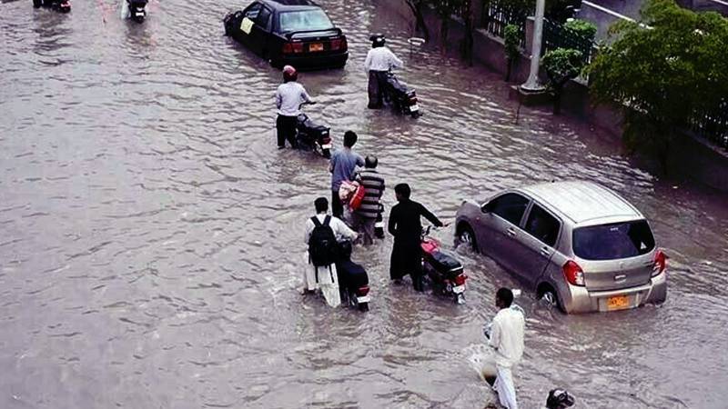
Pakistan is again in a hard monsoon. Cloudbursts in the north, swollen rivers across the plains and stalled drains in the cities have converged into familiar scenes of landslides, broken roads, submerged neighbourhoods and hurried evacuations. The pattern is not a run of bad luck. It is the baseline of a country where geography, climate and planning choices now pull in the same direction.
A map explains the risk. Pakistan runs from ice to mangrove. The northern mountains carry one of the world’s largest stores of land ice outside the poles. Summer heat and long-term warming turn that ice into meltwater which gathers through high valleys and joins the Indus River system. The same system irrigates most of the nation’s arable land, supplies towns and cities and anchors the economy. What keeps fields green can also turn dangerous. Steep catchments speed rainfall into valleys. New glacial lakes have formed where retreating ice left hollows. Far downstream, floodplains and cities sit on ground the river once claimed and will claim again. At the coast, mangroves and fishing settlements hold a thin line against tides and cyclones.
The risks are not uniform. In the mountains, sudden floods come from the failure of natural dams that hold glacial lakes. A shift in ice, a landslide, heavy rain or a small quake can break a dam of ice or loose debris and release a moving wall of water and rock. These are glacial lake outburst floods, and they leave minutes for warning, not hours. Gilgit-Baltistan and Khyber Pakhtunkhwa now host more than three thousand glacial lakes, with a few dozen flagged as hazardous. Local drills, watch posts and simple structures such as siphons, mini dams, gauges and gabion walls reduce casualties but no measure can remove the underlying hazard where ice is retreating and slopes are unstable. Case after case has shown that sound preparation looks like overreaction until the day it does not. It has also shown that engineering will sometimes lose when heat, rain and gradient combine.
Further south the disaster moves slowly. When monsoon rains stack on accelerated melt, the Indus and its tributaries rise and keep rising. Floodwater spreads across the plains and sits for days and weeks. Roads rot, feeder markets are cut off, clinics close and crops drown at the point in the season when a farmer has the most invested and the least ability to move. Because the Indus Basin touches almost everyone, long floods ripple through entire provinces and supply chains rather than harming a corner and moving on. The damage is not only physical. It is also financial and social, widening existing inequalities and pushing those already on the edge into debt and displacement.
Above all, treat every new road, housing scheme and embankment as a flood decision, because that is what it is
Urban flooding adds a third face to the problem. When intense cells of rain meet clogged or undersized drains, water has nowhere to go. Low-lying neighbourhoods in Karachi, Lahore and other cities flood within minutes. Much of the worst damage comes from known choke points where encroachment narrowed nullahs, where wetland was paved for real estate or where culverts were never sized for the runoff that a modern city produces. These failures are not acts of nature. They are acts of paperwork.
Credible forecasting depends on credible observation. Pakistan’s weather observation network is lean for a country of this size and complexity. That thinness lowers the resolution of forecasts and slows warnings when speeds matter. The national disaster authority has improved coordination, daily reporting and seasonal planning and has worked with partners to place more eyes and instruments in the right valleys and basins. Those improvements matter. They also need scale and continuity, not pilot projects that fade after a funding cycle.
It is easy to point across borders and stop there. Neighbours carry a very large share of global emissions and that reality shapes the climate in which Pakistan now lives. Yet rainfall and temperature also respond to natural swings such as the Indian Ocean Dipole, El Niño and La Niña, and western disturbances. The climate signal sets the background. Exposure and vulnerability are set by choices made in planning offices and on construction sites. Building across a river corridor or boxing a nullah is a decision. So is protecting a mangrove belt or keeping a floodplain clear. Finance for loss and damage helps but it cannot unblock a drain in Lyari or widen a channel in Multan without local will and basic maintenance.
Dams and barrages sit at the heart of the national argument every flood season. Storage can save lives by shaving a flood peak. It also stores water for crops and power in a country that needs both. Poorly sited or poorly managed reservoirs uproot communities, trap the sediment that fields need and can fail when storms exceed design assumptions. Free-flowing reaches support ecology and soil fertility and reduce the energy of floods by giving water more room to spread but that choice raises exposure for anyone living where the river will go. The honest position is not for or against storage. It is for an open ledger of trade-offs. That ledger should include sediment budgets, clear operating rules, real resettlement and the discipline to say no where a project puts people in harm’s way or sacrifices soil for short-term gain.
A shared vocabulary helps keep a national conversation precise. A glacial lake outburst flood is the sudden emptying of a lake held by ice or debris, a mountain release that moves faster than sirens. A riverine flood is a prolonged overbank spread when a river exceeds its channel capacity for days or weeks, the slow disaster that does the most damage to farms, feeder roads, schools and clinics. An urban flash flood is stormwater that a city cannot move because its drains are blocked or inadequate, and its watercourses have been narrowed. A compounding hazard is when drivers stack in time or space, for example a heatwave that accelerates melt followed by a strong monsoon pulse over the same basin or a high tide with a coastal storm, a pairing that defeats defences sized for single events.
What would reduce loss is not mysterious. Keep construction out of river space and coastal surge zones through zoning that survives election cycles. Protect and expand Sindh’s mangroves as buffers for storm surge and as working ecosystems that support fisheries. Clear and upgrade storm drains before the monsoon and keep them clear.
Modernise the observation network so forecasts are built on denser, better-sited stations. Publish simple, regular ledgers of closures, spending and outcomes so the country can see what is being done and learn from what fails. Plan storage with transparency and with rules that are known in advance rather than improvised in a crisis. Above all, treat every new road, housing scheme and embankment as a flood decision, because that is what it is.
The 2022 floods serve as a warning that should not be overlooked. At the peak, roughly a third of the country was underwater, affecting about thirty-three million people, resulting in around seventeen hundred lives lost, and incurring damages and economic losses in the tens of billions of dollars. Those figures were not a freak spike. They were the expression of compounding hazards over a vulnerable landscape. Since then, the pattern has repeated often enough to remove doubt about where the trend is pointing.
Pakistan lives from glacier to delta. That line will not move. Choices can. The work now is to keep people out of the water’s path, to give rivers room where they need it, to build only where the ground will stay dry and to match national rhetoric with the small, unglamorous tasks that keep a city standing in the rain. Word by word and culvert by culvert, that is what credibility looks like in a monsoon country.