

Click here for the previous entry in this series
Over the previous four centuries, the course of the River Ravi around Lahore has undergone numerous natural changes. Unfortunately, the history of the River, as indeed of other rivers of Pakistan, has not been documented adequately. Poor education, indifference to environment and a lack of interest in history, has obliterated many memories of our land; memories that needed to be preserved for posterity. However, studying the contours of the land, bits of indirect written records, occurrence of known floods and composition of soil, it is possible to derive scientific conjectures and make educated deductions. Like its course, the name of the river too has undergone change. During the Vedic times (1700-500 BC), the river was called the Purushni or the Irawati. The Greeks (327-330 BC) called it the Hydraotes and the Hyarotis. The Vedic, hence the local, name of Irawati slowly changed to Ravi, which remains prevalent till now.
The books consulted for this article are Tarikh-e-Lahore by KL Kapoor (1882), Lahore; Its History, Architectural Remains And Antiquities by SM Latif (1892), Travels in the Mughal Empire by the French contemporary traveller Dr Francois Bernier, and Storia do Mogor, vol II by the Venetian contemporary traveller Niccolao Manucci. Some maps, particularly dating to 1839, 1867 and 1902 have proved helpful in writing this account.
The Ravi flows from the northeast of the city to the southwest. At its closest, it is now at a distance of two kilometres from the western wall of the Shahi Mosque. Till about a century and a half ago, when the bridges, dams, barrages and canals were not constructed, rivers used to carry prodigious amounts of silt and water, meander at will and frequently change course by miles; especially when the annual floods deposited fresh alluvial soil. Even a change of a few inches in elevation would force the waters to find the line of least resistance away from the existing course. The path of a river, like every celestial body in the universe, is controlled by gravity.
The days of free-flowing rivers, however, are no more, as their courses are now regulated by man-made structures. Their waters are also drawn in large amounts to meet the urban and agricultural water demands of a growing population. With the compulsion to grow more food to feed the fast-growing population (estimated to be around nine billion now in the world), water has become a valuable commodity. Trans-border rivers are now subject to interstate treaties and conflicts.
The Ravi is no exception to these developments. Along with Beas and Sutlej, it was allocated to India under the 1960 Indus Basin Treaty between Pakistan and India. After it exits the hills of the lower Himalayas in Himachal Pradesh, the river’s water is stored and used in India behind three large dams. The Chamera, Ranjit Sagar and Shahpur Kundi dams are hydroelectric dams that store most of the water flowing through this river. Some of this water has to be released downstream due to electricity production. This water, too, is being channelised – first at Shahpur Kundi dam which irrigates about 34,000 acres of land in Indian-administered Jammu and Kashmir, and 5,000 acres in Punjab, and then at the Madhopur headworks where two large canals are taken out to irrigate the fertile lands of eastern Punjab. Thereafter, flowing along the India-Pakistan boundary for about 100 kilometres, the river takes a right turn to enter Pakistan close to the Ravi Syphon. The syphon is where the Bambanwala-Ravi-Bedian-Depalpur (BRBD) canal, originating from Khanki Headworks over the Chenab and flowing south to River Sutlej, crosses under the Ravi. BRBD is the source of the Lahore Canal that enhances the environment of the city.
Considering the probable course of the Ravi in the mid-17th century, it is easily observable that the choice of the site for the Shalimar Gardens, seven linear kilometres to the east from the Fort, was well considered by the Mughal engineers
The Ravi enters Pakistan without a drop of water. However, its flow is restored by feeding it water from the river Chenab through Marala-Ravi and Qadirabad-Balloki link canals. For most of the year, the river obediently follows the track lined by the dams, barrages and the bridges. However, during heavy flooding, when Indian dams spill over, the surging water attempts to reassert its sovereignty, as observed in the floods of 1988, 1993, 1995, 1996 and 1997. Since 1997, there have not been any floods. The 1955 flood was especially massive, with over half a million cusecs of water recorded at Shahdara.
It is well known that the river used to flow along the northern wall of the Shahi Qila. This high wall with no openings at the lower level clearly indicates that it faced the river, which would occasionally rise against it. Another indication of the course of the Ravi is that the site of the shrine of Madho Lal Hussain, constructed during Emperor Akbar’s time, nearly 50 years before the Shalimar was developed, is reported to have been close to the river bank.
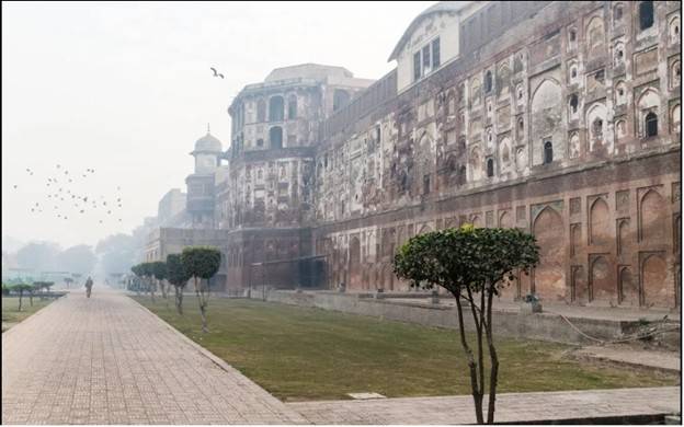
Considering the probable course of the Ravi in the mid-17th century, it is easily observable that the choice of the site for the Shalimar Gardens, seven linear kilometres to the east from the Fort, was well considered by the Mughal engineers. The garden complex, located along the Lahore-Delhi road, must have been in the close vicinity of the river but far enough to avoid being inundated during floods. It is known that the great Ravi flood in the very initial years of Aurangzeb’s reign, that inundated a sizeable portion of northern and eastern Lahore, didn’t affect the Shalimar. The Hasli canal, the one that watered the Shalimar till the Sikh era, originated from near Madhopur.
Thousands of gardeners were employed to look after the garden grounds and trees. To keep them close to their work area, a colony by the name of Baghbanpura, the Colony of Gardeners, was laid out next to the western wall of the gardens. Ironically, whereas the garden complex is laid over about 22 acres, the colony housing its gardeners is now spread over 220 acres. Hasli Canal dried up in late 18th century, but was revived by Ranjit Singh with a channel was taken out of it to provide water to Amritsar.
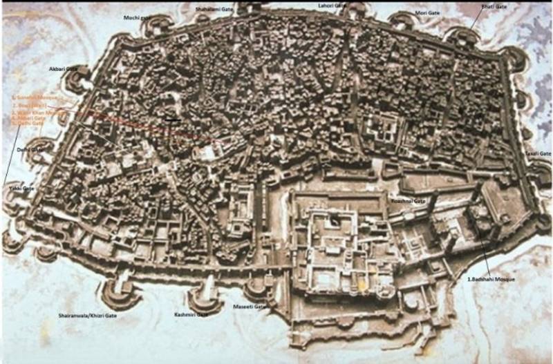
Bernier (ibid) travelled with Aurangzeb from Agra to Lahore and then on to Kashmir in 1666 AD. He was with Aurangzeb on his short stay in Lahore. He wrote that the Ravi having changed its course, the Fort was no longer on the banks of the River. He reported a great consternation among the citizens of Lahore on the river moving away. It was said that the river had changed course due to Aurangzeb’s bund, which, by stopping the river’s natural course, had forced it to move north. In the English translator’s notes dated 1891 to this section of the book, it is mentioned that even at that late date, there were proposals among British officials to divert the river back to its original course around the Fort and the Mosque, but it was not put into execution.
Col Goulding included in his book (ibid, pp-92) a section written in 1860 AD by TH Thornton, the then Secretary to the Punjab Government, stating that in the fourth year of Aurangzeb’s reign in circa 1662 AD, Lahore suffered much damage due to floods in the Ravi. The Emperor had a 3-miles/4.5 km-long bund or embankment constructed to save the city from future floods.
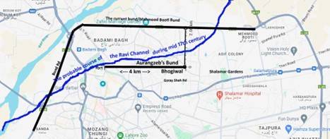
Furthermore, Goulding wrote that in his days, remnants of this bund were visible between the north-eastern corner of the Fort and the village of Bhogiwal in the east. This village lies adjacent to and east of Baghbanpura, and is separated from the University of Engineering and Technology (UET) in its south by the Gorey Shah road. Interestingly, as the Shalimar Gardens were not affected by the flooding, the river must have been at a safe distance to the north. It also indicates that the river took a dip south near Bhogiwal and then turned west to flow along the Fort. Thus, a fairly close proximation of the river course during Mughal era can be reconstructed.
There are clear signs (river sand, canyon, large brick pillars etc) that the main river or one of its large channels continued to flow either through or close to the Mahmood Booty area, which is a mere five kilometres from the city (see the map published with this article); a mere hairbreadth if the river is allowed to take a yawning turn south during peak floods. Passing north of the Mosque, the River channel used to flow west through the low-lying Mohni Road, opposite Taxali Gate. It is known that Aurangzeb arrived by a ship to inaugurate his mosque. Also, some relics relating to a ship building industry have been unearthed in the Mohni Road area.
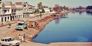
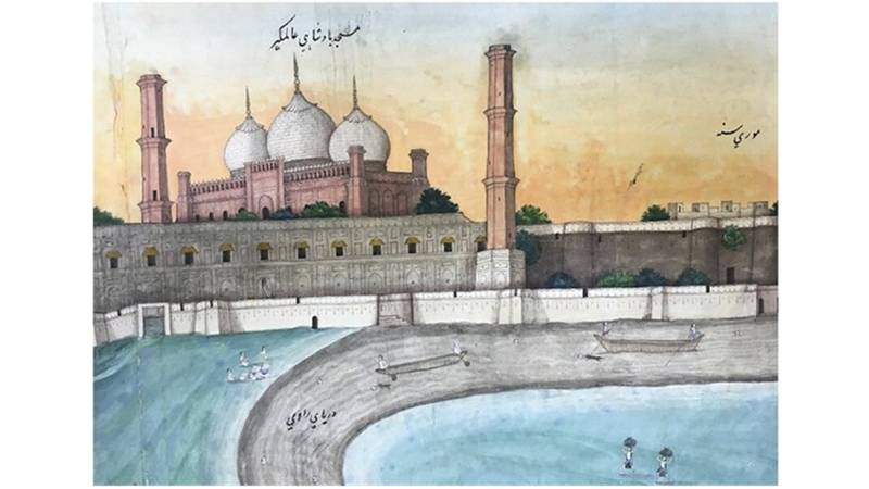
By the end of Sikh rule, the River had changed its course to flow further north, leaving a small channel along the mosque wall. Much later, when that channel largely dried up and moved further away, it was called the Buddha Ravi, meaning the aged or older Ravi. A drawing made in that era shows the channel flowing round the fort and the mosque. In this author’s childhood, the course of the Buddha Ravi existed from Badami Bagh to the Azadi Chowk round the western boundary of the Minto Park. It continued across the Ravi Road, near the Baba Chathriwala (the peer with an umbrella) mausoleum to Karim Park. However, by then it had transformed into a drain and was cut off from the river. Later, when the Minar-e-Pakistan was beautified in the 1980s, the drain was filled with clean water and turned into a lake. That lake vanished when the imposing interchange at the Azadi Chowk was constructed and the roads were widened. Part of the apartment building on the western side of the junction of the Ahmad Ali and Ravi Roads, where the family of this author resided as one of the tenants from 1975 till 1985, was also demolished in that infrastructural development.
There used to be a bridge over the Buddha (or Chota) Ravi between the southwest corner of Minto Park and Azadi Chowk (see the photo above) for traffic from Ahmad Ali Road to Minto Park. This was the remnant of the original bridge built by the British on the Ravi Road for traffic plying between the city and the boat bridge that was located near Kamran’s Baradari. Goulding (ibid) mentions that the Buddha-Ravi bridge was built in 1853-54. It was thought to be too massive for the expected traffic and, hence, called Fagan’s Folly after the name of the design engineer. Goulding (ibid, pp-7) informs us that, when in flood, a huge amount of water used to pass under the bridge in this channel, with water overflowing the banks and submerging the surrounding areas right up to the walls of the Fort. This proves that the Old Ravi may have been old but was still active at that time.
Goulding also mentioned that at about that time a large masonry channel was built past the Taxali Gate to carry the city drainage into Chota Ravi, which at that time flowed a little distance away and joined the main Ravi behind Anarkali’s tomb. This author, living opposite to the bridge, used to cross it nearly every day in 1970s when at home during leave from Air Force duties. The Buddha Ravi had by then turned into a sewerage nullah. However, as Goulding witnessed its annual floods, the Buddha Ravi was live in the early 20th century and used to carry the overflow of the main river that lay about five kilometres away to the north. After the Indus Water Treaty, India stored and diverted the entire flow of the Ravi, killing the Buddha Ravi in the process.
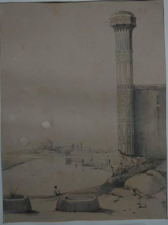
Even as late as the initial British rule in 1850s, one flood channel of the Ravi flowed behind the Civil Secretariat. Goulding (ibid) wrote that it was possible to take a boat from the Veterinary College (a university now), sail past the Commissioner’s Office (now civil secretariat) and go as far as Chauburji. He further wrote that one of the drainage channels from near the courts discharged its contents in this channel. A sketch of Anarkali’s tomb made in 1854 shows a channel of the Ravi flowing past the base of the Chauburji. Since then, the river has moved further west. There is a pencil sketch of Lahore, probably made in the Sikh period, which shows a sizeable channel of water flowing under the northern wall of the Mosque. In a later map, apparently made in the late 19th century, after the railway line to Rawalpindi was laid but the road traffic – still comprising cattle driven carts – used the bridge of boats near Kamran’s Baradari, a channel of water is shown flowing as Buddha Ravi from near Badami Bagh to west of Minto Park and joining the main river near Bilal Ganj, behind the Data Sahib mausoleum. Both maps are provided in this article.
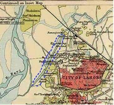
About two kilometres north of the Shalimar lies the locality of Mahmood Booty. The eponymous embankment, along the left bank of the river and its counterpart, on the right bank of the river around the northerly meander, called the Kala Khitai Bund, named after an ancient village a little further upstream, were built to protect northern and western Lahore from the annual floods of the river, especially after the super flood of 1955. The Mahmood Booty Bund, now developed as the Lahore Ring Road, continues along the River to Babu Sabu M-2 interchange and then turns towards Chowk Yateem Khana on Multan Road. On this section of the road is located the road transport hub with stands for trucks and inter-city bus companies.
Given the existence of multiple dams, headworks, weirs and bridges, it is unlikely that the Ravi, or any other river, will ever change course. Extensive engineering knowledge and availability of earth-moving machinery has enabled humans to deny this freedom to the rivers because that would cause immense damage to towns, cities, infrastructure and agricultural lands. The days of free flowing and meandering rivers are behind us.
Note: Annotations on the map are by the author