

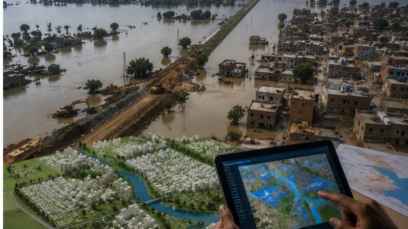
Over the past three decades, the impacts of climate change have made one reality unmistakably clear: our systems of governance, development planning, disaster management, and national and provincial priorities have failed to reduce disaster risks. There are many reasons for this, but one of the most important; and often overlooked, is the absence of effective spatial planning.
Spatial planning is much more than deciding how land should be used. It integrates social, economic, environmental, and infrastructure considerations into a single framework that determines where future development should take place, what type of development is appropriate, and what resources will be needed. In short, it ensures that growth occurs in places where people, infrastructure, and ecosystems are least vulnerable.
The devastating floods of 2010, 2011, 2012, 2020, and 2022, together with the destruction caused by 2025 monsoon, have exposed the consequences of unplanned urban expansion and poor land-use policies. Along the Indus River, the second line of flood protection has gradually disappeared beneath expanding settlements, bringing cities ever closer to the river. Flood management increasingly depends on a single embankment, while densely populated urban areas continue to grow immediately behind it, as seen in Hyderabad. When an embankment breaches, the consequences are catastrophic, resulting in enormous economic losses and human tragedy.
Reports by the World Meteorological Organization/Global Water Partnership (WMO/GWP) and the Japan International Cooperation Agency (JICA), particularly the Executive Study for the Master Plan (JEMA), consistently identify land-use planning as one of the most effective non-structural tools for reducing flood risks. Unlike expensive and often environmentally damaging engineering solutions such as dams, spatial planning reduces risk by preventing vulnerable development before disasters occur.
A major obstacle to effective spatial planning in Pakistan is the widespread encroachment on land by powerful interests. Whether sanctioned through questionable approvals or outright illegal occupation, rivers do not consider them, ultimately obey only the laws of nature. Floodplains, natural drainage corridors, forests, parks, and land reserved for public facilities are increasingly converted into residential and commercial developments, creating a land market worth trillions of rupees.
Such encroachments destroy the landscape’s natural ability to absorb and store floodwaters. Instead of spreading safely across floodplains, water is forced into towns and cities, causing far greater destruction. Preventing this requires strong law enforcement, transparency, and sustained political commitment.
Floodplain zoning is one of the cornerstones of effective spatial planning. International practice classifies land according to flood risk; low, medium, and high, and restricts permanent construction in high-risk areas. Many countries permit only low-impact uses, such as agriculture or parks, within floodplains. These areas temporarily accommodate floodwaters and return to normal use once the water recedes. Global experience clearly demonstrates that without strict zoning and the removal of encroachments, Pakistan and Sindh cannot substantially reduce flood losses.
Urban growth also requires a better balance between expansion and density. Poorly planned urban sprawl exposes new settlements to flood hazards, while excessive population concentration in flood-prone areas magnifies losses when disasters occur. The solution is to direct future expansion towards safer, higher ground while encouraging vertical development in lower-risk urban centres. Bangladesh’s post-1998 flood policies, which promoted high-rise development, provide an excellent example of accommodating urban growth while improving flood resilience.
Spatial planning is much more than deciding how land should be used. It integrates social, economic, environmental, and infrastructure considerations into a single framework.
Accurate flood hazard mapping is equally essential. The JEMA study recommends highly detailed five-metre grid mapping to guide planning and development approvals. Many countries already integrate such maps into their land-use regulations. Although Sindh’s Provincial Disaster Management Authority has prepared flood maps based on past events, there remains an urgent need for more detailed, predictive flood hazard mapping using modern technologies such as LiDAR, satellite imagery, and hydrological modelling.
Strong legal and institutional frameworks are equally important. Weak enforcement of land-use regulations has allowed illegal settlements to flourish in flood-prone areas. Clearly defined institutional responsibilities, better coordination among government agencies, and meaningful penalties for violations are essential. Vietnam’s 2007 Dyke Law, which prohibited settlement in high-risk flood zones and significantly reduced flood-related losses, demonstrates the value of strong governance. In Sindh, institutions such as Planning and Development Board, the Sindh Building Control Authority, the Karachi Development Authority, and the Revenue Department must align their regulations with flood risk reduction objectives and enforce them consistently.
Climate adaptation must also become central to future planning. The JEMA study recommends measures such as elevating buildings, prohibiting construction in low-lying areas and abandoned river channels, and incorporating climate resilience into development standards. China’s “Sponge City” programme, which uses permeable pavements, green roofs, and rainwater harvesting to absorb stormwater, has significantly reduced urban flooding. Although Sindh’s conditions differ from those of Chinese cities, the principles of retaining and managing rainwater remain highly relevant.
Community participation is equally important. Relocating people from high-risk flood zones is politically sensitive and socially complex. Fair compensation and transparent resettlement programmes are therefore essential. Past experiences; from Mangla Dam to Dasu, demonstrate the consequences of inadequate resettlement, while Sindh’s support for communities affected by the Akram Wah project offers a more positive example.
For Sindh, several policy actions deserve priority. Floodplains, historical river channels, and natural drainage corridors along the Indus should be restored, while bridge openings should be widened to allow natural flood flows. Strict No-Build Zones should be enforced along major drainage routes and floodways. Illegal construction must be prevented through coordinated enforcement by the Sindh Building Control Authority, the Revenue Department, and other planning agencies.
Future urban expansion should be directed towards carefully planned satellite towns and higher ground rather than flood-prone areas, while vertical development should be encouraged in safer urban centres. Province-wide, high-resolution flood hazard mapping should become mandatory for all new housing schemes and major infrastructure projects, and these maps should be publicly accessible.
Finally, Sindh should establish an independent and empowered Sindh Floodplain Commission to coordinate planning, land-use regulation, flood risk management, and disaster response across provincial and local government institutions. At the same time, new urban drainage systems and public infrastructure must be designed to withstand increasingly intense rainfall events, while subsidised flood insurance and fair resettlement programmes should protect vulnerable communities, particularly those living along the Lyari and Malir rivers. For Sindh, spatial planning is not simply another development policy. It is an essential investment in resilience—one that can break the recurring cycle of flood disasters, protect lives and livelihoods, and ensure that future development is both safer and more sustainable.