


In the wandering of tectonic plays, nature sometimes plays a cruel joke. Aeons ago, it created a bottleneck in the waters at the entrance to the Persian Gulf in the form of a narrow strait. That passage serves as a vital link between several civilisations in Mesopotamia or, as Arabs called it, Bilad Al-Rifadayn – both meaning Land between the Rivers – and the nations on the Indian Ocean rim, especially the ports on the western coast of India. The trade brought pearls and dates from upper Gulf ports to the rich markets of India, and spices and silk on the return voyage.
Hormuz has been a witness in the modern era to the successive might and grandeur of the Abbasids, the Mongols, the Safavids, the Ottomans, the Arabs, the Portuguese, the Dutch, the British, the Ayatollahs, and the USA. That is ten overlords in as many centuries. Now the Chinese and the Indians have a heavy reliance on the Strait to quench their thirst for petroleum, a vital commodity for their upward economic and military trajectory, and would like to ensure free passage. In ancient times five thousand years ago, these narrows served as a link between the Sumerian Civilisation in the lower reaches of the Euphrates River and the towns in the Indus Valley Civilisation. In our century, there is an unceasing flow of ships passing through these waters – at about a hundred per day before the war started – and scores of fishing and pleasure boats.
One advantage of reading history is the certainty of the ephemeral nature of this world. Predicting the political or geographical future is not possible, but forecasting a change is easy. It will happen. This Strait, as indeed some other straits, will continue to be of value as a trading route and prone to conflict.
Hormuz has been a witness in the modern era to the successive might and grandeur of the Abbasids, the Mongols, the Safavids, the Ottomans and the United States
A cursory look at the satellite imagery of the Strait reveals that the geological separation of Persian and Arab plates at the location of the Strait was tortuous, as if the land was resisting the tremendous forces created by the movements of the tectonic plates. It left behind contours that are as jagged, in satellite image view, as any of the fjords of northern Norway, and, like a troubled divorce that leaves the children distributed, this division of geological plates has left straits, islands, and peninsulas scattered all over the chasm.
The geographical separation that created the Persian Gulf has, as it often does, cast a long shadow on the ethnic schism as well: Arabs on its western and Persians on the eastern shores, heirs to different ethnicity, civilisation, language, literature, and religions. There are rocky outcrops on the Musandum peninsula on the Omani coast, and its Persian seaside is dry, barren, and hilly. The Persian towns, including Bandar Abbas and Minab, remained a place where the two nations intermingled. The water channels close to Iranian coasts are deep. Even the narrow strait between the small Larak and the large Qeshm islands is 35 to 100 metres deep, allowing large, fully loaded tankers with a draught of up to 25 to 30 metres to sail through safely. This passage is only 10 kilometres wide and, during the current US-Iran standoff, has been designated as a safe zone by Iran for ships that pay toll.
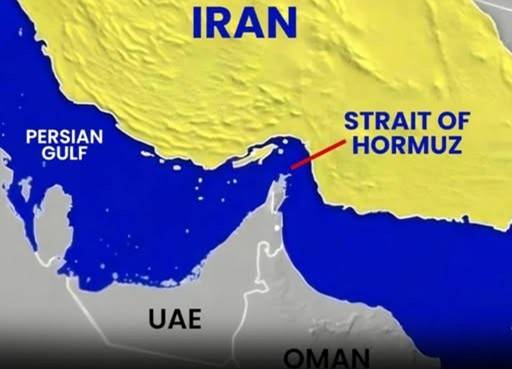
On the whole, in the Gulf of Oman at the entrance of the Strait, the seabed is deeper on the Oman side as compared to the Iranian side, but the Persian Gulf is much shallower on the Arabian side, which has enabled Dubai, with a water depth of 10 metres along its coast, to create three bunches of artificial islands, all named different kinds of Palm. With the rapidly melting glaciers, much of this artificial development will sink under the gulf waters even with a rise of a foot in the water levels.
The weather on the Iranian side of the Strait is extremely hot, humid, and hazy throughout the year. Bandar Abbas receives less than ten inches of rain in a year and experiences ten months of warm to sweltering hot weather. There are eight major islands in the strait, seven of which are under Iranian control, though the ownership of Abu Musa, Greater Tunb, and Lesser Tunb islands is contested with the UAE. Iranian control of these islands enhances Iranian influence in the waters of the Strait.
Nature didn't play the only humour in the creation of the Strait; it had another surprise hidden under the sands of the coast around it. In the early 20th century, crude oil was discovered under the surface, and that too at shallow depths. It is said that the Bedouins around the town of Dhahran – the city where this author spent three years controlling air traffic on its airfield while deputed by PAF to RSAF – would be disappointed to find a thick, smelly liquid instead of sweet water. The combined crude output of the Gulf rim now is 25% of the total world production, and the majority of that passes through the Hormuz. The average size of large tankers at 400 metres long and 60 metres wide is four times the length of a field hockey ground and as wide. That is huge, and they must pass through the Iranian sovereign waters to commute in the Strait. Before the current US-Iran war, Iranians allowed free passage to all ships, but now employ this trump card against Trump-led aggression as a money-earning asset.
The only large city in the Strait is Bandar Abbas on the Iranian coast. Its earliest mention dates back to 500 BC during the reign of Darius the Great. His Greek navigator, reportedly launched from a Strait port, found a sea route to the Indus River and the Red Sea. When Alexander the Great conquered Persia, the city was known as Hormirzad. Writing in 1512, the Portuguese sailor, Duarte Barbosa, described its people and social environment as, "The Persians are tall and well-looking, and a fine and up-standing folk, both men and women. They hold the creed of Muhammad in great honour. They indulge themselves greatly, so much so that they keep among them youths for the purpose of abominable wickedness. They are musicians, and have instruments of diverse kinds." The town, then called Gamrun, was conquered by the Portuguese in 1514. The Safavid rulers of Iran captured the city and renamed it as Bandar Abbas after their Shah. It is a modern town now of nearly a million people.
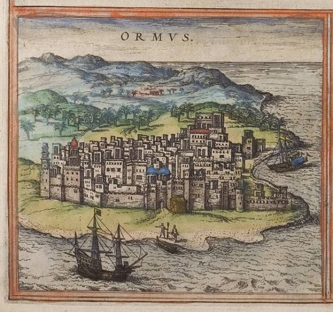
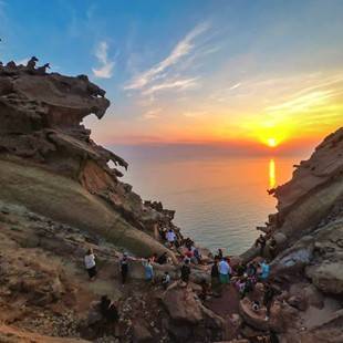
The Portuguese continued to control the sea trade and voyage from the island of Hormuz, where they established a fort. It is from Hormuz that they introduced the Cartaz system of extracting a heavy shipping toll, to exercise a monopoly on trade and travel in the upper Arabian Sea. In 1622, under the impetus of Shah Abbas, an Anglo-Persian force evicted the Portuguese garrison from the island too. Iranians gained control of the Strait and the British a monopoly over trade in the region. The island was formed 600 million years ago but emerged from water nearly 50,000 years ago – about the time when Homo sapiens were themselves emerging from their long evolution. The port of Hormuz was originally located on the southern coast of Iran to the east of the Strait of Hormuz, near the modern city of Minab. However, during the Mongol occupation, its local ruler shifted the port to the island which is about ten kilometres from the Iranian shores. Minab would forever be remembered as the site of a massacre, an inglorious chapter in US militarism, where in the opening salvo of attack on the 28th of February, they bombed a girls' school, killing 168 children.
Oman had a strong naval presence in the region when the Portuguese and the western powers found the sea route round the Cape of Good Hope to the Indian Ocean. Despite European presence, Oman continued to hold itself as a viable sea power and extended her empire from both sides of the Straits to Bahrain. In the 17th and 18th centuries, under pressure from Oman and the western naval forces, the Arab Al-Qasimi tribe, efficient seafarers themselves, converted their base in Ras Al-Khaimah and Sharjah to piracy. They attacked western shipping with impunity for over a hundred years before the combined Anglo-Oman forces occupied these coastal towns and put an end to what the British termed as piracy. Even now, a Google search for the terms 'The Pirate Coast' will yield results indicating that it means the UAE coast, especially Ras Al-Khaimah. Between 1820 and 1892, the British signed treaties with all seven states—Abu Dhabi, Dubai, Sharjah, Ajman, Umm Al Quwain, Fujairah, and Ras Al Khaimah – to create a British protectorate. These seven Trucial States, as they came to be called, ruled by individual tribes, converted to the independent country of the United Arab Emirates in 1971. That is where the political geography of the region rests now.
The next article on the subject will discuss the economic geography of this Strait.