

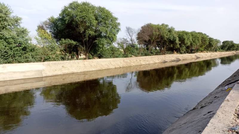
In a recent press briefing, Ms. Azma Zahid Bukhari, the provisional Minister for Information in the Government of Punjab, dismissed concerns regarding the failure of the Rajasthan Canal, claiming that Indian efforts to green their part of Thar Desert had already yielded results. She stated that the region, which lies on the border of India and Pakistan, had been transformed into fertile land, a feat that her government proudly attributed to the canal’s ambitious irrigation project. However, an in-depth satellite analysis reveals a starkly different picture—one that casts significant doubt on the success of this monumental undertaking. The satellite data reveals a troubling reality about the effectiveness of the Rajasthan Canal and raises questions about the true extent of the "greening" that has occurred.
The Rajasthan Canal was originally conceived as a large-scale irrigation project designed to bring water to the arid desert landscape of Rajasthan, with hopes of transforming barren land into productive agricultural fields. As one of India’s most significant irrigation endeavors, it spans a vast area, and its success—or failure—carries immense implications for the region’s agricultural development and its economic future. However, the claims made by Ms. Bukhari regarding the success of the canal contradict the hard data presented through recent satellite analysis.
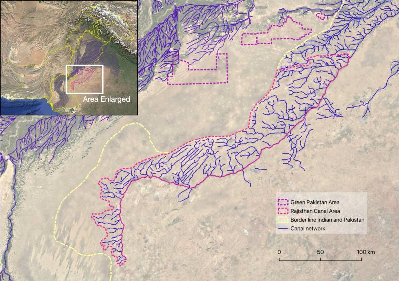
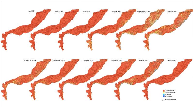
Utilising publicly available satellite data from the Sentinel-2 L2A platform, we analysed the moisture index of the Phase II Rajasthan Canal Command area, which spans approximately 3.8 million acres of land. This satellite data, commonly used by organisations like Green Pakistan’s Land Information Management System (LIMS), offers a clear, scientific understanding of the area’s moisture content and agricultural viability. The moisture index, which ranges from -1 to +1, helps classify the land’s condition: values approaching -1 indicate barren or desert land, while values closer to +1 suggest healthy land with little to no water stress. The data was analysed monthly from May 2024 to April 2025, revealing concerning trends about the region’s environmental conditions.
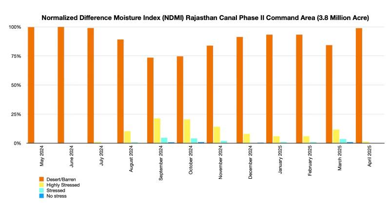
From May 2024 to April 2025, the moisture index exposed a grim reality for the Rajasthan Canal Command area. During April through July 2024, a staggering 99% of the region remained barren, showing negative moisture index values. These results unequivocally confirm that, far from greening the desert, the canal’s impact has been minimal, with large swathes of land effectively being reclaimed by desertification. Despite the immense infrastructure and investment poured into the project, these findings suggest that the area is still predominantly arid and largely unproductive.
The data reveals that the canal has not been the transformative force that was hoped for, and instead, it has exposed the limits of large-scale irrigation projects in desert regions
Between August 2024 and March 2025, the situation showed only slight improvements. A tiny fraction of the land—ranging from 0.07% to 0.95%—showed no water stress, which stands in stark contrast to the more optimistic claims made by officials. This tiny percentage falls far below the 1% threshold cited by Indian officials as proof of success. Meanwhile, 0.37% to 4.6% of the area experienced moderate water stress, and between 5.9% and 21.2% of the land was categorised under high water stress. Taken together, these figures reveal that despite the significant investment in canal infrastructure, the region continues to suffer from water shortages and desertification. The data further shows that, on average, a staggering 73.5% to 99.8% of the land remained barren throughout the year, confirming that the canal has not had the desired effect on transforming this harsh desert landscape into fertile, irrigated farmland.
Further corroborating this troubling data, satellite imagery paints an even bleaker picture of the Rajasthan Canal's legacy. The once-promising canal infrastructure, which was designed to irrigate vast stretches of arid land, has largely been overtaken by shifting sand dunes. These dunes have buried the canals over tens of kilometers, rendering them completely useless for irrigation purposes. The satellite images also show the failed attempts to level the land to facilitate canal irrigation, with most of these efforts resulting in little more than barren earth. This imagery underscores the severity of the challenges faced by the project and highlights the gap between expectations and reality.
Despite the well-documented challenges, the Rajasthan Canal was initially hailed as a lifeline for agriculture in one of India’s most drought-prone regions. But this data-driven analysis shows that the canal’s ability to deliver on that promise has been severely limited. While the Indian government has tried to market the canal as a success story, the satellite evidence clearly points to the canal’s ineffectiveness in addressing the fundamental challenges of water scarcity and desertification. The canal has not been able to significantly improve the region’s agricultural productivity, and large parts of the command area remain barren and unable to sustain crops.
This satellite-driven analysis not only debunks the claims made by Ms. Bukhari but also highlights the significant difficulties faced by the Rajasthan Canal project. The data reveals that the canal has not been the transformative force that was hoped for, and instead, it has exposed the limits of large-scale irrigation projects in desert regions. The failure to meet the expected outcomes has led to growing public resentment, particularly in the areas most affected by the canal’s shortcomings. Communities that were promised a greener, more prosperous future are instead dealing with the harsh realities of a failed venture, which has not delivered on its promises.
In light of these revelations, it is clear that the concerns raised regarding the canal’s effectiveness were well-founded. The claim made by Ms. Bukhari, which dismissed these concerns as unfounded, appears to be at odds with the available data. Furthermore, by presenting misleading information to the public, the minister may have violated the Pakistan Electronic Crimes Act (PECA), which holds individuals accountable for spreading misinformation. This failure serves as a stark reminder of the complex realities of large-scale irrigation projects and the environmental and climatic challenges that often undermine their success.
Ultimately, the satellite imagery and data analysis paint a picture of a project that has largely failed to meet its goals. Despite the significant infrastructure and ambitious vision behind the Rajasthan Canal, it has been unable to transform the desert landscape into the thriving agricultural hub that was once promised. The project’s inability to combat desertification and improve agricultural productivity highlights the limitations of grandiose irrigation plans in regions with challenging climatic conditions.