


The Ravi River’s return after decades of decline stirred emotions across Punjab, but the story of the eastern rivers—the Ravi, Sutlej, and Beas—runs deeper than a fleeting flood. Allocated to India under the 1960 Indus Waters Treaty, these rivers have been profoundly reshaped by dams, barrages, and diversion projects. The scale of upstream infrastructure explains why Pakistan today receives little more than trickles from rivers that once carried vast flows.
The Infrastructure of Control
India has constructed a formidable chain of storage dams on the eastern rivers. The Bhakra Dam on the Sutlej, with nearly 7.5 million acre-feet (MAF) of live storage, and the Pong Dam on the Beas, with 6 MAF, dominate this system. The Ranjit Sagar (Thein) Dam on the Ravi adds another 0.8 MAF, while the Pandoh and Shahpur Kandi dams provide supplementary capacity. Together, these reservoirs amount to roughly 14.83 MAF of cumulative storage.
Because these dams regulate nearly all seasonal flows, the Ravi delivers only a small residual trickle into Pakistan, while the Sutlej contributes virtually no water outside the monsoon season. To compensate, Pakistan constructed a network of link canals that divert large volumes from the Indus to sustain the Sutlej and Ravi systems, supporting irrigation across Punjab.
On its side, Pakistan also relies heavily on its own mega-dams. The combined live storage of Tarbela (9.7 MAF) and Mangla (8.4 MAF) exceeds the cumulative capacity of India’s eastern river reservoirs by about 32%, reaching 20.77 MAF, with several smaller dams adding further capacity. Nor does it end there: beyond Tarbela, Khyber Pakhtunkhwa hosts around ten additional dams, while Punjab, in addition to Mangla, has about eight. Complementing these are 15 headworks and barrages in Punjab, and two major—along with several smaller—barrages in Khyber Pakhtunkhwa. By contrast, Sindh has no dams at all, but it does control three very large barrages.
While India’s upstream structures curtail Pakistan’s access to the eastern rivers, Pakistan’s dams and diversions in Khyber Pakhtunkhwa and Punjab play a parallel role downstream—determining how much water ultimately reaches Sindh.
It is not just India’s dense network of dams and diversions that has curtailed Pakistan’s eastern flows; Pakistan’s own reliance on mega-dams and link canals has similarly constrained water availability in Sindh
Evidence of Declining Flows
The flow record bears this out. From 1976 to 1998, Pakistan received an average of 9.35 MAF annually from the Ravi. That figure fell to just 2.96 MAF in the period from 1999 to 2022—a 68% decline. With the completion of the Shahpur Kandi Barrage, even this residual flow is expected to disappear.
For the Sutlej and Beas, long-term flow data is sparse, but the reality is blunt: outside the monsoon, they no longer reach Pakistan at all.
| River | Control | Flow (1976–1998) | Flow (1999–2022) | Reduction (MAF) | Reduction (%) |
| Ravi | India | ~9.35 MAF | ~2.96 MAF | ~6.39 | ~68% |
| Sutlej | India | Not available | Not available | – | – |
| Beas | India | Not available | Not available | – | – |
The Larger Basin Context
A broader view of the Indus Basin shows that while both India and Pakistan face shrinking flows, the steepest declines occur within Pakistan’s own system. Western rivers under Pakistan’s control have dropped by 11% since the late 1970s, while eastern rivers under India have plunged 68%. More strikingly, at Panjnad Barrage, where the five rivers of Punjab converge, flows have declined by 65%. At Kotri Barrage, the last major control point before the Indus reaches the Arabian Sea, flows have fallen 64%, dipping below 10 MAF in nearly half of the past 25 years.
| Category | Control/Location | Flow (1976–1998) | Flow (1999–2022) | Reduction (MAF) | Reduction (%) |
| Western Rivers | Pakistan | 135.6 | 120.8 | 14.8 | 11% |
| Eastern Rivers | India | 9.35 | 2.96 | 6.39 | 68% |
| Panjnad Barrage | Pakistan | 20.5 | 7.5 | 13.0 | 65% |
| Canal Withdrawals | Pakistan | 102.73 | 95.85 | 6.88 | ~7% |
| Kotri Barrage | Pakistan | 40.7 | 14.8 | 25.9 | 64% |
The following AI-generated infographic vividly illustrates the steep decline in water flows recorded at Kotri Barrage.
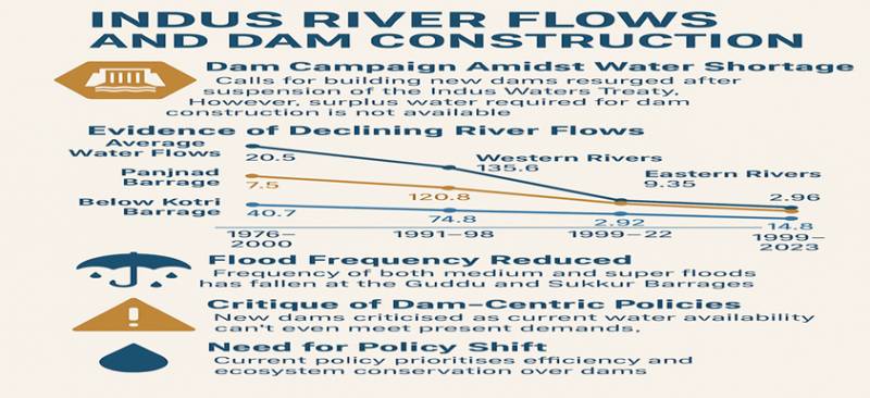
At Panjnad Barrage near Uch Sharif in Bahawalpur, the Indus, Jhelum, Chenab, Ravi, and Sutlej are finally brought together before flowing toward Sindh. From there the combined river moves southward to Sukkur Barrage and beyond. Yet the 65% reduction in flow observed at Panjnad is nearly identical to the decline on the eastern rivers controlled by India, highlighting how infrastructure within Pakistan compounds scarcity. By the time the Indus reaches Kotri, flows are severely depleted, threatening the delta and livelihoods dependent on it.
The table above shows that canal withdrawals, reduced by only 7%, represent the smallest decline among all categories of infrastructure. The heart of the matter lies in control. Punjab’s extensive network of 15 major headworks and barrages, together with its intricate web of canals, grants it a degree of authority over water that Sindh lacks simply because of its geographic position downstream.
When the monsoon swells the rivers, Punjab’s water managers do not merely watch—they act. By opening gates and diverting water into link canals, they achieve two vital goals. First, they avert disaster by reducing the risk of catastrophic flooding. Second—and this is the province’s crucial advantage—they transform excess floodwaters into an asset, particularly during normal monsoon seasons: enriching the soil, replenishing groundwater, and turning what might have been destruction into a massive, cost-free irrigation system. In this way, Punjab, by virtue of its location, converts a seasonal hazard into a "blessing in disguise," reinforcing both agriculture and long-term water security.
Lessons for the Future
The evidence points to an uncomfortable truth: infrastructure, not only treaties, dictates water reality. It is not just India’s dense network of dams and diversions that has curtailed Pakistan’s eastern flows; Pakistan’s own reliance on mega-dams and link canals has similarly constrained water availability in Sindh.
If water is to remain a lifeline rather than a flashpoint, both countries must confront the hidden role of infrastructure in transforming natural rivers into political tools. For Pakistan, the urgent task is not only to negotiate with India, but also to reassess how its own choices—from Panjnad to Kotri—determine scarcity downstream. Recognising infrastructure as the silent negotiator of river politics may be the first step towards reshaping water governance across the basin.
The views of experts may have some valid reasons for advocating the construction of additional dams on the Indus River. However, the statistical evidence presented here suggests that such endeavours, without a deeper understanding of their downstream consequences, may ultimately prove very harmful.