In the previous article in this series, the journey from Babusar Top to Gilgit was recounted. This part of the travelogue describes the town of Gilgit and our stay in it.
Gilgit is a strategically located historic town. It sits on the right bank of the River Gilgit. The city lies at the confluence of river Gilgit, carrying the glacial waters of the eastern Hindukush and River Hunza, that drains the western slopes of the Karakorum. The road heading east along the River Gilgit connects the town – through Phander, Mastuj and Shandur (of polo fame) – with Chitral and further to Afghanistan. Another road branches off north across the rivers Gilgit and Hunza to join the Karakorum Highway (KKH) leading to Khunjerab Pass and on to Kashghar in Xinjiang, China. In the opposite direction, KKH connects the town with the plains of the Subcontinent. A little south of the town, another road – in fact the only road – plying west along the Indus, connects the rest of the country with Skardu, Leh and Tibet. Buddhist and Gandhara traditions remained strong here for a long time till the 8th century AD, as the archeological finds and rock inscriptions testify.
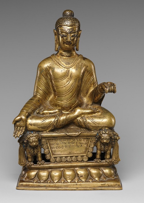
Enthroned Buddha found in Gilgit (circa 600 AD)
Any perceptive mind can perceive that the town has as much Central Asian character as Subcontinental, and is a global roundabout connecting the world with China and Central Asia. Its history includes Chinese occupation, Chinese travelers to the region and many incursions through modern-day Xinjiang, including one by Mirza Haider Dughlat, a cousin of Emperor Babur. The ancient history of Gilgit and its links with the Chinese Empire have been covered in detail by B. Prakash in his scholarly work Gilgit in Ancient Times. The Kashmir Valley has been integral to the Indian subcontinent since ages but the Indus-Hunza Valley beyond Jaglot has had better access with Central Asia through Xinjiang and Wakhan. In fact, till the British took interest in the region as part of the Great Game in the early 19th century, Chinese, Uyghur and Tibetan influence remained strong here.
Gilgit sits in a bowl of stone. All around the town, we saw tall mountains with rocky faces and, as elsewhere in the Indus Valley, without any vegetation. There was little greenery on the hilly slopes with massive rocks glaring down on the valley. In peak summers of our visit, these stony walls reflected sunlight during day and shed their heat at night. Resultantly, the interior of the bowl was intensely hot. The heat evaporates copious amounts of water from the Gilgit and the Hunza, both mighty rivers, and numerous smaller streams flowing through the valley. The result is hot and humid weather with little rainfall.
The vendor complained that the town receives only a little of the large amount of fruit grown in Hunza Valley, as most of it is transported to Islamabad and Punjab. Excellent roads allow the fruit picked there to be sold in Peshawar, Islamabad or Lahore markets
The sight of snow over Rakaposhi (7,788 m/25,551 ft) to the northeast did little to mitigate the scorching heat. For six months, the town sizzles with temperatures of 30°C to 35°C and humidity above 30%. There is not a single month in the whole year when the average rainfall exceeds one miserly inch. The two nights that we spent there were the most uncomfortable of the whole trip. In winter, though, Gilgit is very cold with January low temperatures dipping to subfreezing point.
We spent one day in the town but were restricted to being indoors. We went in the evening to NLI Market on the western end of the town, but were thrown off track on to River View Road due to a sit-in on the main Jinnah Road. A ten-minute drive turned into a slog of 45 minutes as we were caught in a traffic jam. This was our first taste of the sit-ins. This one only caused discomfort, but the others that we encountered later would ruin our last leg of the trip.
It so happened that being a Friday, the market was closed. However, though we missed the main shopping, most of which would have been superfluous, we did manage to get the essentials, i.e. spectacles for my wife (she broke hers in Kaghan) and an electric kettle to make tea. On the way, we tried buying some cherries, but the price was more than in Islamabad. The vendor complained that the town receives only a little of the large amount of fruit grown in Hunza Valley, as most of it is transported to Islamabad and Punjab. Excellent roads allow the fruit picked there to be sold in Peshawar, Islamabad or Lahore markets within twenty-four hours, and in Karachi within two days. Reversely, Sindhri mangoes were being sold in Gilgit at Islamabad rates of about 200-250 rupees per kg.
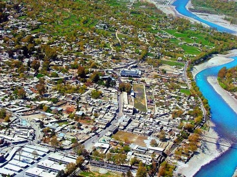
Gilgit: the city and the river
People of Gilgit are very soft-spoken and friendly. Everyone speaks and understands Urdu. Shina, the local language, is of Aryan origin and not hard to understand. We lost our way once due to a dharna-forced diversion around the airport and found the people eager to help. The staff in hotels, restaurants and markets were extremely courteous.
The Gilgit Valley is narrow and a score of kilometers wide on each side of the confluence of the Gilgit and Hunza rivers. On the south of the river Gilgit, where the town exists, there is barely a kilometer-wide clearing between the hills and the river. The terrain here is rock hard, without much top soil and, therefore, unfit for crops. On the western side, along the Chitral Road, the valley terminates where the river flows out from a narrow gorge. On the eastern side, the terrain is hostile and narrow on right bank of the river up to its merging with the Indus and beyond. On the left bank of Hunza River opposite Gilgit town, large clearings with fertile river soil facilitate some agriculture. Water is in abundance and temperatures high; both conducive for crops. Potatoes are a favorite produce in the entire Gilgit-Baltistan. It is a cash crop as well as easy to store for snowbound long winters. We saw many apple orchards too.
Gilgit is a one-road town, as all small towns are. Approaching from Jaglot, four kilometers short of the city center, the KKH turns right to cross the Gilgit River. The left branch of the road is now called the Gilgit road because it leads to the town. As it crosses the Jutial Stream, it is called Shahra-e-Quaid-e-Azam and passing through the town center, it takes a sharp turn to the river around the airport runway and changes name to Park Road. At the bank of the river, it again turns sharply to the west and is named Chitral Road or Gilgit-Shandur Road. The Airport Road that skirts the airfield on all sides, the River View Road along the right bank of the River and the Punyal or the Shaheed-e-Millat Road in the foot of the hills on the western end, are only loops of this main road. As was stated above, the valley is too narrow to support much of a population. The GB government must plan now to accommodate the expanding population before the whole town becomes a slum. It is already a maze of narrow streets where traffic can easily get blocked.
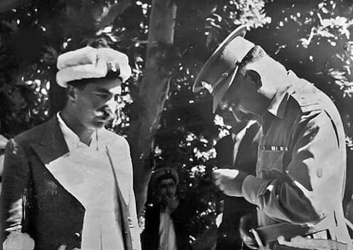
Maj Gen Ghansara Singh surrendering to R.M. Babar
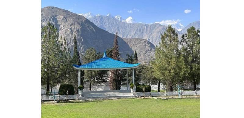
Sitting in the sprawling lawns of FCNA officers' mess, in the searing heat of Gilgit, as I looked around at the tall cheerless surrounding mountains and the ubiquitous white Rakaposhi in background in the east, I recalled that Gilgit-Baltistan had become part of Pakistan by the heroic actions of a few officers of Gilgit Scouts. Had these brave sons of the soil not acted under their own initiative, the area would certainly have come under Indian occupation.
On the 1st of November 1947, Subedar Major R.M. Babar with four Viceroy’s Commissioned Officers namely, Subedar Major Muhammad Babar Khan, Jemadar Shah Khan, Subedar Safiullah Beg, Jemdar Shah Sultan and Jemadar Fida Ali, arrested the Dogra governor Maj Gen Ghansara Singh from his residence; not far from where I sat in my easy chair. The Gilgit Scouts then marched on to Skardu in snow, to draw the border where it stands now. For three months, the area remained under the control of the Scouts before Pakistan sent a Political Agent to take charge of the vast area. Indians continue to regret this loss. The Air Force fondly remembers Jemadar Shah Khan S.J., SI(M), who was later commissioned in the service, retired as a Group Captain and was instrumental in setting up the skiing facilities at Naltar valley; which was our next stop in this trip. R.M. Babar and Shah Khan were scions of royal houses of Nagar and Hunza respectively.
The next part of this travelogue will narrate our visit to Naltar Valley and the abrupt end to our trip.
N.B. One of my readers asked me to include sight- as well as site-seeing. I hope I have covered both.
Parvez Mahmood retired as a Group Captain from the Pakistan Air Force (PAF) and is now a software engineer. He lives in Islamabad and writes on social and historical issues. He can be reached at: parvezmahmood53@gmail.com