The China Pakistan Economic Corridor (CPEC) is a very well-thought-out and executed project. The various road networks – many of which have already been completed – linking the Gwadar Port on the Makran Coast right up to the Karakorams have created a reliable trade route. In fact, this route can ensure that shipments from the Persian Gulf and the Indian Ocean make it to China in record time, while bypassing strategically vulnerable chokepoints in the Straits of Malacca and the South China Sea.
But there is one major flaw in this transportation network. Even though there are multiple roads leading to Gilgit-Baltistan from the rest of Pakistan, there is only one border crossing point, i.e. the Khunjerab Pass in Upper Hunza. Having such an important trade artery rely on one transit point is a rather dangerous proposition. The Khunjerab can become a choke-point just like the Straits of Malacca – and if it were to close due to various reasons such as political unrest, external military action or even a major natural disaster such as an avalanche or an earthquake, the entire CPEC trade would come to an abrupt halt. Therefore, it is imperative that alternate routes to the Khunjerab be found and roads built over them.
There exist several options, but each of them comes with its own particular difficulties, both geographic/natural and political. Perhaps the easiest route is one that lies west of the Khunjerab, and the time is ripe to start its development.
Let us consider some of the options.
The first place to look would be in the vicinity of the Khunjerab itself. In the past, the Khunjerab Pass was rarely used for trade purposes: it is a very high and inhospitable plateau and would often be subject to raids by the Kyrgyz of the Taghdumbash Pamir. The two passes adjacent to the Khunjerab, namely the Kilik and Mintaka Passes, were far more popular routes. The reason why the Khunjerab was chosen to be the conduit of traffic between Pakistan and China was because the gradient of the Khunjerab was less steep and thus easier to build a road over. Thus, the Kilik and Mintaka would require too much civil engineering in the form of tunnels and bridges and would be massive financial projects. Given the expertise and economic might of the Chinese, this would not be a major impediment. But the larger fact remains that they lie in the same valley as the Khunjerab and thus would be prone to the exact same limitations. If the road were blocked between Karimabad and Upper Gojal, all three passes would become inaccessible. Thus, it would not be feasible to choose these two as viable alternatives.
Currently, talks and feasibility reports are ongoing for another CPEC route over the Karakorams. The Skardu-Shigar-Yarkand highway over the Muztagh Pass is being touted as the most reliable alternate to the Khunjerab. Building this road would be an engineering marvel, as it leads over the cluster of 8,000-metre peaks that build up to the second highest point on the face of the earth, the mountain K2. Furthermore, this is a region known as the Third Pole and contains the greatest amount of glacial ice outside of the Arctic and Antarctic. The environmental impact of building a highway and the emitting massive amounts of carbon from vehicular traffic in such a sensitive area would be something unaffordable in the already severely damaged ecosystem of the present day. This route is also fairly close to the Line of Control with India – and its troops and airbases in Kashmir and Ladakh pose an ever-present threat. For all these reasons, the Muztagh Pass route would be a very difficult one to build, upkeep and protect.
Yet, there is a route which has not been mentioned so much in discussions on this issue. Let us consider it.
The Khunjerab was chosen to be the conduit of traffic between Pakistan and China because the gradient of the Khunjerab was less steep and thus easier to build a road over
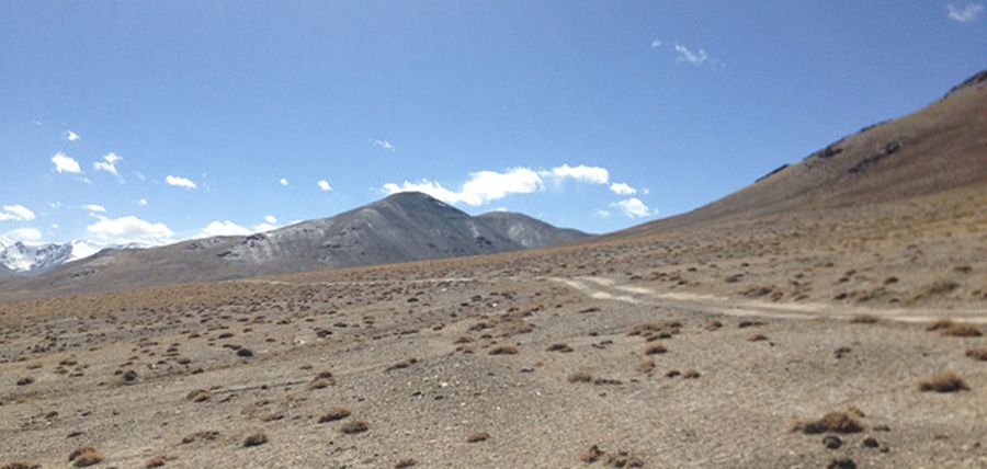
The route that we are about to discuss offers the shortest distance between the plains of Pakistan and the Chinese border. For hundreds of years, traders from Peshawar, Bajaur and Swat used the route leading into Chitral and then following the length of its river up to the Boroghil Gap and the Wakhan to reach Xinjiang. From the Wakhan, they would cross the Wakhjir Pass and in a matter of days would be Tashkurgan – from where the routes to Kashgar, Yarkand and Khotan lay open. Even after the Afghans closed the border between Chitral and Wakhan in the 1930s, Hajis (Muslim pilgrims) from Xinjiang would still use the routes to go to Chitral and the after crossing the Lowari they would be at the Railway Station in Dargai within two days – and from then on, their journey would be entirely on the North Western Railway network until they reached the port of Karachi. The major hurdle used to be the Lowari Pass. But since the Lowari Tunnel was completed in 2017, this is no longer a hindrance. Once the Dir-Chitral Motorway is completed, the drive from Islamabad to Chitral Town will be a mere six hours compared to the eleven-hour journey to Gilgit. From there onwards there exist no major geographical obstacles, and all that would be required would be to build a two-lane road along the river passing Mastuj and the Yarkhun Valley up to Boroghil. Now, Boroghil would be better described as a gap rather than a pass, as it is a unique geographical point where the High Hindukush parts and an open grassland gradually declines down to the bed of the Oxus. From there, it is less than 50 km of Afghan territory to cross until you reach the base of the Wakhjir Pass. A road already exists on the Chinese side, linking the Wakhjir to Tashkurgan.
Road to the Wakhjir Pass
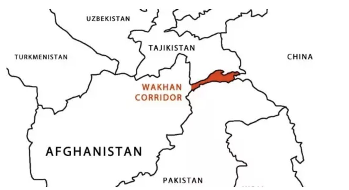
The only issue with this route is a political one, the fact that traffic will have to transit via Afghanistan – even if it is only a very short distance – to reach China. There can be several solutions to this problem. In this day and age of global finance, everyone wants a piece of the pie. A government in Afghanistan is no different. China and Pakistan can give many incentives to Afghanistan to allow unhindered access through the Upper Wakhan. The current Taliban administration in Kabul would be more than ready to agree to such an arrangement. The re-establishment of this ancient trade artery – once used by everyone from the Bactrian Greeks to the Tibetans to Marco Polo for crossing through the Wakhan – would bring unprecedented prosperity to not only Chitral but also, and especially, Badakhshan of which Wakhan is a part. Also, the Wakhan offers easy access to Tajikistan, which lies just across the Oxus and can serve as a conduit of One Belt One Road trade, linking CPEC with the Central Asian arm which goes through Tajikistan and Kyrgyzstan. It would also open up Pakistani vehicles to travel to Tajikistan and the large market that is Uzbekistan. Both Dushanbe and Tashkent can receive goods from Gwadar and Karachi using this route. and as Uzbekistan is already connected to the trans-Eurasian road and rail networks, it could mean access for Pakistani goods all the way to Russia and even Western Europe.
Pakistan and China are both countries which have an immense amount of influence in Afghanistan and now is the perfect time to develop the Wakhjir route which is the only viable alternative to the Khunjerab. Nothing but co-prosperity can result from this – and that, too, in one of the most remote parts of the globe.
The author is the ceremonial Mehtar of Chitral and can be contacted on Twitter: @FatehMulk
 The first place to look would be in the vicinity of the Khunjerab itself. In the past, the Khunjerab Pass was rarely used for trade purposes: it is a very high and inhospitable plateau and would often be subject to raids by the Kyrgyz of the Taghdumbash Pamir. The two passes adjacent to the Khunjerab, namely the Kilik and Mintaka Passes, were far more popular routes. The reason why the Khunjerab was chosen to be the conduit of traffic between Pakistan and China was because the gradient of the Khunjerab was less steep and thus easier to build a road over. Thus, the Kilik and Mintaka would require too much civil engineering in the form of tunnels and bridges and would be massive financial projects. Given the expertise and economic might of the Chinese, this would not be a major impediment. But the larger fact remains that they lie in the same valley as the Khunjerab and thus would be prone to the exact same limitations. If the road were blocked between Karimabad and Upper Gojal, all three passes would become inaccessible. Thus, it would not be feasible to choose these two as viable alternatives.