One of my endearing memories is standing in the cupola of the tank, talking on the wireless set with a mug of tea in one hand and a map in the other. All three were indispensable but the map was also my friend. It told me where I was and how to get to my destination. It told me what features the ‘enemy’ could defend and how best to approach them without exposing my tanks. It also told me where there was a clump of trees to conceal my troops and the names of all the villages in the area. With the grids on the map I could register the ‘enemies’ location which the aircraft and artillery could engage with accuracy. The map we were taught to ‘read’ at the military academy had a scale of one-inch i.e. an inch on the map corresponded to 1000 yards on the ground. Therefore, it contained detailed information e.g. single huts, lone trees, contours spaced out at a 100 yards – in short all the necessary information for the commanders and troops of a tactical units within an accuracy of 6 yards.
If you look closely at a one-inch map sheet, at varying intervals you will see a small triangle with a number e.g. 556. The triangle is the symbol for a triangulation (trig) point (usually marked on ground by a concrete or stone pillar) and the number denotes its height. They are always located at the highest point in the surrounding area from where one or more trig points can be observed with a theodolite – a precision instrument for measuring angles in the horizontal and vertical planes. Trig points form a network of triangulation based on which a follow-up topographical survey accurately establishes the exact positions of villages & town, boundaries, roads, railways, bridges, etc. across the entire country. Therefore, the trig points lie at the heart of accurate mapping which in the subcontinent commenced 218 years ago in 1802.
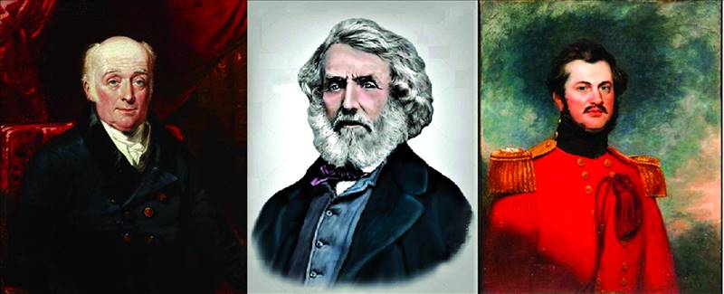
Ten years ago I chanced upon a book in a second hand store that I now treasure. It’s called The Great Arc and is about the largest land survey attempted in the world. It was initiated by the Madras Presidency in 1802 and taken up by the Presidencies of Bombay and Bengal. The architect behind this idea was William Lambton, a British officer who displayed his survey skills by navigating by stars during the Fourth Anglo-Mysore War. His proposal for conducting a survey of the territories captured by the British in Southern India were supported by Major General Arthur Wellesley (later the Duke of Wellington) and approved by Robert Clive. As the shadow of the East India Company spread over the subcontinent, so did this great survey and was continued by Sir George Everest and his successor Andrew Waugh.
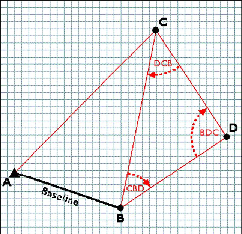
A survey commences with marking and measuring a baseline. From the two terminals of the base line (A and B), the angles and elevation of a third point (C) are measured with a theodolite thus forming a triangle. The length of the sides i.e. the distances AC and BC can be calculated with trigonometry. Line BC forms the next baseline to measure point D and so on. This seemingly simple process is called triangulation. However, the larger the area to be surveyed, the bigger the base line should be and more accurate its measurement.
The first precision baseline was established by Lambton in Madras in 1802. It was of 7½ miles and the latitude and longitude of its terminals were registered through astronomical observations with a Zenith Sector – a telescope attached to a 5-foot-long sector that pointed straight up to the skies. It took 58 days to complete the measurement with a Ramsden chain consisting of 40 links of 2.5 feet each and measuring 100 feet at 62° Fahrenheit. Hundreds of calculations had to be made to factor expansion / contraction of the chain caused by temperature variations, and repeated observations with the Zenith sector had to be taken to determine errors in latitude. The ideal triangulation distances were 20 miles but it depended on the terrain and visibility. From the camp at an established trigonometrical station, a team would be dispatched to the next projected station to erect a signal tower on a hill or ridge. It sometimes took weeks of waiting for the team to arrive at the location where the tower was to be erected and the right conditions to obtain an observation with the theodolite.
The Great Theodolite was probably one of the only two or three instruments in the world sophisticated enough to serve Lambton’s purpose of mapping the south of India with inch-perfect accuracy and an error rate of a mere 0.002%.
The theodolite was not the shoe-box size that you see surveyors standing with on the roadside but a massive half-ton apparatus with finely calibrated micrometers, microscopes and spirit levels to provide precise measurements. In his book The Great Arc, Keay writes that the Great Theodolite was probably one of the only two or three instruments in the world sophisticated enough to serve Lambton’s purpose of mapping the south of India with inch-perfect accuracy and an error rate of a mere 0.002%. In the process he also confirmed through his trigonometrical survey what Newton had calculated with gravitational forces, that the earth was not spherical but like a grapefruit.
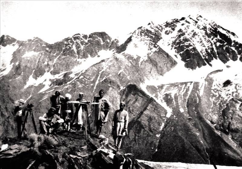
The surveyors who worked on the Great Trigonometrical Survey of the Indian Subcontinent in the colonial era. L-R - William Lam
From Madras, the series of trig stations were extended to the western coast of India through Bangalore and then taken south to Kanyakumari (Cape Cameron). Additional baselines had to be established throughout the network for adjustment purposes. Principle triangulation points throughout the network were selected for astronomical observations and geodetic positioning to adjust their position initially determined with triangulation. Lambton needed a huge team of 150 including escorts, signalmen, porters, mahouts and runners, with whom he trekked through jungles and swamps and crossed rivers, fighting disease and fever. When making line-of-sight observations proved difficult because of trees and other intervening features, the half-ton theodolite had to be hoisted to the top of a bamboo, stone or mud tower constructed for this purpose. When an attempt was being made to haul the Great Theodolite atop a temple, a guy rope broke and the instrument crashed against the tower. Lambton took the mangled theodolite to a military workshop and confined himself to his tent for six weeks during which he dismantled the instrument, had it repaired and brought it back to its original shape.
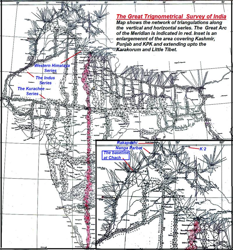
In 1818, Lambton became aware of an officer who had a talent for mathematics and astronomy and had conducted a 400-mile survey in Bengal for a Semaphore Line (optical telegraph using flags or mirrors). His name was George Everest (pronounced Eev-rest and not Ever-ist), and in 1818, Lambton appointed him as his chief assistant. That same year, the triangulation survey was officially given the name of Great Trigonometrical Survey and started extending north along a single series of triangulations that Lambton named the Great Indian Arc of the Meridian. An arc of longitude running north-south on the Earth’s surface is called a meridian and the survey roughly followed the 78th East Meridian from Cape Comorin at India’s southern tip to the foothills of the Himalayas. However, the survey would expand far beyond a single arc. Ultimately it would comprise of four large lateral and over thirty large and small vertical series forming rectangles all of which would ultimately be filled with smaller triangulations covering the whole of the subcontinent. But that would take many more years.
On Lambton’s death in 1823, Everest succeeded him as superintendent of the GTS and over the following years extended the arc up to Sironj, near Bhopal. He redesigned the theodolite and made it more compact and replaced the steel chain with more portable 10-foot bars that whose length did not change with variations in temperature. In 1830, Everest was appointed Surveyor General of India and during his tenure, the Great Arc was completed in 1841 up to Banog in the Himalayas near Mussoorie, a length of 2,400 km. It was done under the supervision of his chief assistant, Andrew Scott Waugh who was an engineer officer. When Everest resigned in 1842 after 20 years of work on the Great Arc, he managed to have Waugh replace him.
Triangulation - from the 2 terminals of the baseline (A and B), the angles and elevation of a third point (C) are measured with a theodolite. Line BC then forms the baseline for measuring D
Under Waug’s supervision the Himalayas were surveyed from Sona Khoda near Darjeeling till Dehra Dun fixing the heights of over 90 peaks over a distance of 1,700 miles. It took many months for a team of human computers to calculate, analyze and extrapolate the trigonometry involved. In 1852 their team’s leader, Radhanath Sikdar informed Waugh that Peak XV was the highest point in the region and most likely in the world. It took four years for Waugh to ensure that there was no error, and published the result in 1856. His proposal that the peak be named Mount Everest in honour of his predecessor was accepted. Waugh’s major contribution was establishing a gridiron system of traverses for covering northern India that was quicker and more accurate than the triangulation method.
On Waugh’s initiative, two longitudinal series were extended westwards to the region that now encompasses Pakistan. From a fresh baseline established at Dehra Dun, a North West (NW) Himalaya Series extended towards Attock, and the Kurrachee (Karachi) Longitudinal Series headed west from a baseline established at Sirong north of Bhopal. Work on the NW Himalayan Series commenced in 1847 even before the East India Company had annexed the Punjab. However, due to tribal disturbances along the foothills, it took six years to reach Attock via Gurdaspur, Sialkot and Jhelum with 77 principal triangles covering a distance of 416 miles i.e. approximately one triangulation per month. The Kurrachee Series took just as long though it involved 173 principal triangles over a distance of 688 miles. Working over the rugged Aravalli mountains, then through the Great Thar Desert, north of Rann of Kutch and finally across the Indus valley to Karachi, after five seasons of very severe weather, the last angle of the series was taken at Magar Pir (Munghopir) Station, in April 1853.
At Kurachee (Karachi) another base line was measured for the southern end of the Great Indus Series. The northern end would terminate at the Chuch Doab east of Attock which was most suitable for a fresh baseline because the ground was more level than at any previous site in the entire subcontinent. The plain was also studded with ancient mounds and the terminals were placed on two of them. Both the baselines were established under Waugh’s personal supervision and the triangulation commenced at both ends with the triangles connected halfway. From Kurachee till Sukkhur the triangulations followed the west bank of the Indus and then astride it with one flank in the Derajat and the other in the Sind Sagur Doab. The surveys were interrupted halfway by the revolt of 1857 but resumed a year later. The entire 700 miles of the Indus Series was completed by 1860 with 2,925 principal triangles requiring 148 stations, most of which had to be placed on towers because of the flat river valley. A year later Waugh retired.
Waugh’s assistant who later replaced him was George Montgomerie, another engineer officer who was only 25 years old when he worked with the Surveyor General on both the base lines of the Indus Series. Soon after this he started work on the survey of Kashmir working through river valleys of Poonch, Jhelum, Kishanganga (Neelum) and Kaghan. Sir Clements Robert Markham was the secretary of the Royal Geographical Society between 1863 and 1888, and in his book A Memoir on the Indian Surveys published in 1871, he provides an account of the survey of this region.
“In the summer of 1855, Montgomerie extended the series across the Pir Panjal Range. Two of the stations were 13,000 and 15,000 feet above the sea. Building materials had to be dug out of the snow for the station pillars, and the observers were detained at one station for 22 days, owing to snowstorms and foggy weather. Afterwards, as the parties penetrated into the mountains, the height of the stations averaged 17,000 feet, and luminous signals were used from peaks, 19,000 and even 20,000 feet above the sea.”
During the survey of the Kashmir Series, Montgomerie fixed the height of Nanga Parbat and Rakaposhi, and when he extended it onwards to the Karakorum, he fixed the height of a peak registered as K2, at 28,290 feet.
One cannot but admire the dedication and energy of these Surveyor Generals and their teams who most of the time worked under harsh conditions to map the Indian Subcontinent. The results they produced were so accurate that when their surveys were checked with modern instruments, a century later, it is not surprising that the variations were miniscule.