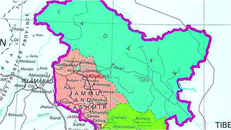
On November 2, India’s Home Ministry issued a new political map of India’s territorial jurisdictions. The map follows the illegal decision by the current Indian government to annex Occupied Kashmir, an internationally-recognised dispute awaiting the exercise of the right to self-determination by the peoples in the three divisions of Jammu, Kashmir and Ladakh.
The issuance of the map on November 2 comes on the heels of the Jammu and Kashmir Reorganisation Act, 2019 taking effect on October 31. Much has already been written on how Article 370, which gave special status to Occupied Kashmir, was ambushed by tweaking Article 367 and then applying the provisions of Article 3 to re-carve the boundaries of the disputed and occupied part of the State of Jammu and Kashmir. We shall, therefore, not go into that detail and stick to the move by India to try and recast the political map.
What does it signify, if at all?
Not much in legal terms. That be so, why should Pakistan be worried? Here’s how it goes.
Pakistan’s Ministry of Foreign Affairs has already rejected the move to map Occupied Kashmir as two Union Territories and “displaying Jammu and Kashmir region and seeking to depict parts of Gilgit-Baltistan and Azad Jammu and Kashmir within the territorial jurisdiction of India,” calling it “incorrect, legally untenable, void and in complete violation of the relevant United Nations Security Council Resolutions.”
The MoFA statement also makes clear that the new political map is “incompatible with the United Nations’ maps.”
The statement is correct in all these respects.
Political maps are political declarations. The problem arises if other states begin to accept the altered map and start presenting it as India’s territorial boundaries in their own documents and textbooks, though the chances of that are slim to nil. Also, India’s move is to be seen in conjunction with its political declarations that the move to annex an occupied territory is its (India’s) internal matter.
That is a blatant falsehood. The United National Security Council resolutions make it very clear that India has no title to Occupied Kashmir, just like Pakistan has no title to Azad Jammu and Kashmir. The State of Jammu and Kashmir, as its territorial boundaries existed on the eve of August 14, 1947, remains a disputed territory. This is precisely how the UN maps depict the area. Until such time that a plebiscite is held to determine the wishes of the peoples of the formerly princely state, no state has any title to it.
That said, the case of Azad Kashmir and Gilgit-Baltistan is different in that both areas were liberated by the people through an armed rebellion against the ruler of the princely state. For India to show AJK and GB as part of its territories is therefore an even bigger fraud than the one it has perpetrated on the hapless peoples of Occupied Kashmir.
A word about maps. Unlike geographical and/or geological maps, which depict physical, over- and underground topographic realities, political maps are declarations and unless such declarations have wide acceptance, they merely remain unilateral declarations. They work in the UN system only to the extent of lines that are internationally recognised and accepted. This is why even the UN maps have no primary evidentiary value in the event of disputes. As for disputed territories, the UN maps present the ground situation neutrally. In other words, unless there is other corroboratory evidence, the maps in a dispute do not have much value under international law.
Let’s put it another way. India’s revocation of Article 370, which provided New Delhi a tenuous link to the disputed and occupied territory is Pakistan’s and Kashmiris’ problem not because either had accepted its legality but because India has violated both the provisions of UNSC resolutions as well as fundamental tenets of the Simla Agreement of 1972. Neither on the basis of UNSC resolutions, nor under the terms of the bilateral Simla Agreement, India can unilaterally change the status quo.
The point about Simla Agreement is crucial for a simple reason: India has long defrauded the international community by referring to that Agreement as the basis for resolving all outstanding disputes between itself and Pakistan. One of the three principles of the Agreement reads: “To uphold the inviolability of the Line of Control in Jammu and Kashmir, which is a most important CBM [confidence-building measure] between India and Pakistan, and a key to durable peace.” The map issued by India and statements by that country’s top political and military leadership expressing their irredentist designs on AJK and GB are in clear and blatant violation of the aforementioned principle. Moreover, India’s attempts to ingress into AJK and constant firing and shelling across the Line of Control are equally a violation of the principle stated in clear terms in the Agreement.
The Agreement further states that “the two countries are resolved to settle their differences by peaceful means through bilateral negotiations or by any other peaceful means mutually agreed upon between them. Pending the final settlement of any of the problems between the two countries, neither side shall unilaterally alter the situation and both shall prevent the organisation, assistance or encouragement of any acts detrimental to the maintenance of peaceful and harmonious relations.” (italics mine)
The text goes on to say: “In Jammu and Kashmir, the line of control resulting from the cease-fire of December 17, 1971 shall be respected by both sides without prejudice to the recognised position of either side. Neither side shall seek to alter it unilaterally, irrespective of mutual differences and legal interpretations. Both sides further undertake to refrain from the threat or the use of force in violation of this Line.” (Italics mine)
It’s imperative to iterate and reiterate these facts because India is again (a) trying to defraud the world and (b) the world is asking both countries to resolve the issue bilaterally and peacefully. It is important, therefore, to establish that India’s actions on August 5, Oct 31, and Nov 2 are in complete violation of the letter and spirit of Simla Agreement, signed on July 2, 1972.
The world powers have to understand that the onus for shutting down the bilateral window is entirely on India.
But this is not all. Another crucial point relates to the fact that both India and Pakistan are bound, as per the language and text of the Agreement, to respect and adhere to the UN Charter and its principles: “That the principles and purposes of the Charter of the United Nations shall govern the relations between the two countries…”. (Italics mine)
This is a clear statement that bilateralism is intrinsically tied in with the acceptance of the world body as an arbiter and its resolutions in respect of the Kashmir dispute, far from being diluted by ‘bilateralism,’ are further strengthened, especially if any side seeks to unilaterally change the status quo, which is precisely what India has sought to do since August 5.
To recap: India’s action on August 5 is untenable, illegal, unconstitutional and arbitrary both on the benchmark of its own constitutional requirements (A G Noorani’s book is a definitive work on the centrality of article 370 and how it has been diluted over the years) as also against the letter and spirit of the UNSC resolutions and the Simla Agreement; Kashmir, both on the basis of UNSC resolutions and Simla Agreement, is not India’s internal affair; India’s undemocratic action, taken without any consultation with the peoples of Occupied Jammu and Kashmir, fails all the tests: legal, moral, democratic and normative; India is trying to give a fait accompli to the world; by issuing the new maps and by making statements with reference to AJK and GB, India has expressed its politico-military irredentism which is a highly destabilising act; the world needs to take cognisance of India’s actions and the consequences flowing from them; finally, India has interred bilateralism and the only arbiter left now is the world body and its relevant organs.
All of this said, since we are on the subject of maps, Pakistan needs to get its own act together. It still can’t decide its map. The Punjab Curriculum and Textbook Board shows Pakistan, Gilgit-Baltistan, AJK and IOK all in one map. All the boundaries are shown separately and labelled. IOK as disputed territory, AJK and Gilgit-Baltistan separately. The Survey of Pakistan, meanwhile, does not approve of the PCTB map. In SOP maps J&K is one territory and all of it is marked as “disputed territory.” However, the SOP maps do not show GB as ‘disputed territory’.
The Indian maps show the whole of Kashmir including Gilgit-Baltistan, Shaksgam Valley (Area ceded by Pakistan to China) and Aksai Chin, which is IOK’s part but is controlled by China. Our maps are not very precise because the PCTB map shows Shaksgam as Pakistani area and Aksai Chin as part of IOK.
Speaking to some sources I was told that the publishers are in a fix about what to do with the map of Pakistan because concerned governmental agencies raise objections to how the map is depicted in textbooks. The result is many different maps.
It would seem eminently sensible that while we must reject unilateral maps put out by India, we should get legal and international law experts to advise the government — in light of our position — on how we should depict territories that are disputed and get a single, approved map. This is not just an exercise in cartography, but is also important in politico-legal terms.
The writer is a former News Editor of The Friday Times. For a 101 on maps he is grateful to his sister, a geographer. He tweets @ejazhaider reluctantly