“It’s a flat country and people understand everything in that context, including floods” says Masood-ul-Mulk the CEO of Sarhad Rural Support Programme, the award winning organization working in Khyber Pakhtunkhwa for the last eleven years. “When we mention floods, people immediately visualize large expanse of land inundated with river waters and hundreds of people displaced and that is the image of flood inflicted damage that is more familiar. When we talk of devastation caused by the recent floods in Chitral, it is hard to imagine its implication without the familiar images”, he says. “But if you understand the topography, social and economic structure and the systems in place, you will realize that the damage done to it has been astounding and it might take decades to fully recover from it”.
District Chitral has been badly hit this year by some of the worst flooding in its history. The damage has been massive and the expanse of land effected, enormous. The causes behind this year’s floods and its magnitude need in-depth research and the KP government must make it a priority in order to be better prepared for the future.
Even with a brief visit to some of the worst affected areas and listening to eyewitness accounts, it is possible to analyse and come up with initial findings, however in no terms, conclusive.
Even a moderate flood next year could cause the hillside to collapse
In order to find out the reasons and witness the ramifications of the floods I travelled to district Chitral and from there onwards to the remote Bumboret village in Kalash. The four-day travel in flood hit areas, seeing the realities on ground and listening to a lot of people was very educative in terms of understanding the various dimensions of recent floods and the extent of damage they had caused. I was accompanied by a young man from Kalash People’s Development Network, an organization working in Bumboret and he guided me all the way from Ayon to Kalash. The trek was rugged and difficult. The road had been washed away at many places and the bridges were all gone. The only way to cross the river was by a makeshift bridge made of wooden planks and hanging by rope. It was definitely not for the faint hearted.
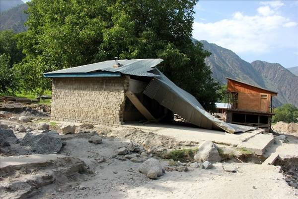
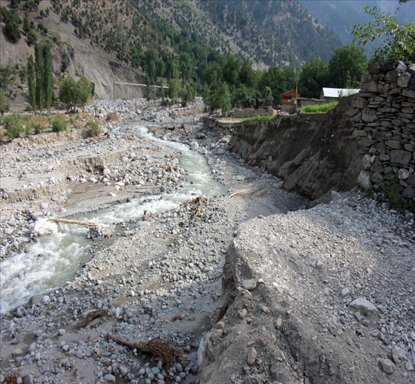
We crossed over the river, climbed up the rocks to find the remaining road; and when it disappeared, we climbed down again to the river to find an alternate route along the river and up the mountain again. So up and down the rocks we travelled for some twenty kilometers before finally reaching Bumboret. The signs of devastation caused by the flood were evident everywhere. The houses, hotels and shops built along the river were all washed away without a trace and the river bed was littered with huge boulders, the size of small houses. The water marks left by the flood levels were unbelievable. The water has risen to unprecedented heights and has not spared anything in its path. Its ferocity and volume has been a massive force the likes of which had not been seen by anyone in living memory.
The small bridge crossed by the expedition
Bumboret is surrounded by mountains and is flanked by two glaciers, the Shiwal glacier and the Zinor glacier. On the night of August 16 the people in the village were alerted by the Frontier Corps Check post situated high up the mountains that a massive flood was coming and the villagers had about two to three hours to get out of its way and save their lives. At 2 o’clock in the morning a massive landslide of heavy rocks and uprooted trees smashed into the village carried by gushing black water and big boulders of ice. The whole village shook on its foundations and the infrastructure and the construction along the river crumpled within minutes. The colour of the water, the massive rocks it carried and the sudden bursting gives the indication that it might have been a GLOF phenomenon (Glacial Lake Outburst Flooding). The flood water was definitely coming from the massive glacier melt which was unprecedented in volume and had great velocity.
The houses built at a height, up the mountains, were spared by the floods but they had still become vulnerable nevertheless. The reason being that owing to the massive rocks and boulders carried by the hill torrents the bridges have been destroyed and the damming at places had caused the river to actually change its course and move to a new channel it has carved, splashing along the hill side with all its cold might. The most vulnerable places in Bumboret include a place called Salojalik, where more than two hundred families reside and which has some of the most glorious farms and fruit orchids.
The whole place is now at risk as the river can and probably will erode the exposed hill side, the next time it decides to strike with its full might. Even a moderate flood next year can cause the hillside to collapse. The only way to save it is to remove the boulders damming the river upstream and reroute the river in its old channel. I cannot exactly say how much effort and resources would be needed to manage that, if at all, or how much of a priority that would be considering that hundreds of places in several valleys are vulnerable now and have similar stories to narrate.
Chitral is an immense district in terms of its total area and it is actually twenty percent of the total area of Khyber Pakhtunkhwa. However, only one percent of the population resides there. There are thirty two valleys in the district and hundreds of villages scattered in them. The population of most of the villages was dependent on small private hydropower stations for the provision of electricity. After the recent floods, hundreds of water channels have been destroyed along with the small hydro power stations and the villages have been plunged into darkness.
The livelihood of the people in these villages is mostly based on small subsistence farming which was dependent on the water channels and because of the floods that has been affected badly. According to the survey by SRSP, just from Ayon village to Chitral, which is a distance of some forty kilometers, seventy eight water supply channels have been destroyed. The people used to drink spring water but that has now also been polluted and is not fit for drinking anymore.
The crops have been badly affected because there’s no water and even the livestock has suffered because of the lack of fodder. The valuable produce from the valleys is fruits and dry fruit, including walnuts, pomegranates, apples, apricot which will be badly affected this year in terms of both quality and volume. Also crops like potatoes produced in large quality, in several valleys, would be affected. Even more alarming is the fact that because of the collapsed roads the farmers have no way to access the markets and hundreds of tons of agricultural produce, including fruits and vegetables will not reach the main markets. That will obviously be a heavy blow to the economy of the whole region and would be a major factor in enhancing poverty.
There is an urgent need for the government of Khyber Pakhtunkhwa to focus all its attention on the rehabilitation of the damaged road infrastructure and building of the bridges so that the people are connected to the main land and their produce can reach the markets. If immediate steps are not taken then the already vulnerable people would plunge into further poverty.
The reasons behind this year’s flood can evidently be found in climate change which has affected the weather patterns and the amount of rainfalls in the region. This year the summers started early and the snowmelt had been more than usual. The glacier melt and the excessive rainfall is the major reason behind the floods.
There is no readymade or immediate solution present to control either the climate change, glacier melt or the floods in the coming years. There are only two possible strategies available for combating the effects of climate change and that is, Mitigation and Adaptation.
If the government wants to save the region and the people from the ill-effects of climate change and floods then there is a need for a comprehensive strategy for mitigation and adaptation which would include but not limited to, awareness raising of the people, making strict laws for conservation and management of river basins and training of the people for reducing their vulnerabilities, alternate energy sources, sustainable livelihood practices and community based disaster risk management.
The government also needs to make all efforts to control the illegal cutting of trees and make afforestation a priority in the flood prone areas. KP Government must also ensure that there is no tree plantation or construction in the river basin. The people must be made aware of the dangers they pose for everyone if they violate the law. Strict action should be taken against the people constructing in the prohibited area. Vulnerability assessment as well as need assessments should be done in order to come up with better planning and better resource allocation. The government should try to make strategies for rebuilding keeping in view the socio economic realities and practices of the area and adapt to that accordingly.
The situation in Chitral is not an isolated example of an erratic natural disaster and it must be understood that it is a warning for everyone regarding the realities and impact of climate change. The people of the whole region will be affected by the medium and long term impacts of these floods and both the federal and provincial governments must make the rehabilitation of the devastated valleys a top priority.